Descripción
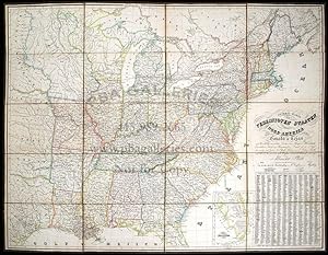
PLATT, Albrecht (1794-1862). General-karte der Vereinigten Staaten von Nord Amerika, Nebst den Grösst. Theilen von Canada & Tejas: Mit Bezeichnung Sämmtlicher Cantons, Deren Haupt-u. Handelstädte, Eisenbahnen, Kunst- & Hauptstrassen, Canäle etc. etc. Magdeburg: Fr. Kaegelmann, 1847 Fine folding engraved map (29 x 37 inches) laid down on linen in 20 sections, showing the eastern United States up to and including states bordering the Mississippi, showing early and unsettled areas west of the Mississippi. Also, shows portions from Texas straight up to Canada (including the Dakotas, present-day Montana, Nebraska, Oklahoma, etc., an inset of Florida appears lower right, all with original hand-colour in outline, the title and key lower right. An interesting and early map showing Texas bordered by the Sabine and Red Rivers, but only extending as far as Austin in the west, not far enough to show San Antonio. The land to the north of the Red River is given as "West Gebiet", or western landscape. Texas was admitted to the United States in 1845, and the information in this map is essentially the same as appears in Disturnell's Mapa de los Estados Unidos de Mejico. New York: J. Disturnell, 1847, which follows White, Gallaher & White's 1828 map, itself based on Henry Tanner's landmark 1826 map. Tanner's map had greatly improved upon previous cartographic efforts in the region in numerous regards. However, his most significant action was to redraw New Mexico's southern border eight miles further north at the western end and eighty miles further north in the east. Disturnell retained this significant amendment in his map and, thus, when the U.S. Government under President Filmore selected Disturnell's map for negotiating a new border after the Mexican-American War, Tanner's revised boundary passed into law. Both Spanish and English versions of the map were included as official documents in the 1848 Treaty of Guadalupe-Hidalgo. N° de ref. del artículo 72map409
Contactar al vendedor
Denunciar este artículo
![]()
