Descripción
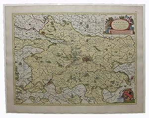
Single sheet, (21 x 24 5/8 inches; 18 x 21 7/8 to the neat line; full margins showing the plate mark). Magnificent engraved map of the province of Namur in Belgium, with ORIGINAL COLOR BY A SKILLED HAND, the individual cities shown in different bold watercolors of pink, green, and yellow and HEIGHTENED WITH LIQUID GOLD, decorated with a fine compass rose pointing north with a GOLD-ENHANCED FLEUR-DE-LIS, surrounded by a border of yellow wash (short marginal tear not affecting image, old central fold, slightly toned). BRILLIANTLY HAND-COLORED map of the province of Namur (Namen) in southeastern Belgium with ELABORATE LIQUID GOLD HIGHLIGHTS. Decorated with TWO STRIKING CARTOUCHES: one flanked by putti and instruments of war above the distance scale, and the other a coat of arms with a cherub. A small compass rose colored in red and green sits near the top of the map within the image. Several fortified cities are illustrated and named, including Huy, Ghiney, Dinant, Bouignes, Fontaine, Charleroy, and Giblou, with notations for churches, castles, forests, and mountains. Originally published by the second Nicholas Visscher, a new edition of this map was later published by his son Nicholas (1649-1709) in his monumental work "Atlas Minor" (1680). Versions were also issued by Peter Schenk and Frederick De Wit in "Atlas Maior" (as here) at the end of the 17th century and subsequently reprinted in various editions. The Visscher family was one of the most distinguished of all 17th-century cartographic firms, and a major player in the era now considered the golden age of Dutch mapmaking. In the late 1600's, a period of great geographical discovery, Amsterdam became an international center of the arts and of cartography, with engravers and printers produced magnificent maps and charts of every kind. The fields of artistic production and mapmaking were arguably more seamlessly united during this era than any period before or since, as the strong competition among publishers meant that maps not only had to be scrupulously accurate, but also visually appealing. In this milieu, a number of venerable firms, including those established by Blaeu, Jansson, Hondius, as well as Visscher, competed for the ever-expanding market for maps and atlases. The firm founded by Nicholas Visscher set standards for exceptional quality that few others were able to equal, and Hendrick de Leth, who eventually rose to assume control of the Visscher publishing house in the 18th century, maintained the company's standards for excellence during a period when Amsterdam's cartographic preeminence was just beginning to be challenged by the French school of scientific cartography. N° de ref. del artículo 72MMS255
Contactar al vendedor
Denunciar este artículo
![]()
