Descripción
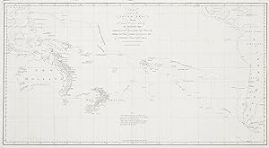
Seminal map in the charting of the Australian continent and the most up-to-date chart of the Pacific for its time. The chart records the discoveries made by Cook on his first voyage 1768-1771, in the Endeavour which are shown for the first time, including the charting of the east coast of Australia and New Zealand. With Cook's charting of the east coast, the geographical limits of the South Land were finally now known. The map also includes the tracks and discoveries of Wallis, Carteret and Byron. The discovery of Tahiti and the recording of its longitude are important and often overlooked achievement of the Wallis expedition as they paved the way for future cartographic advances and further exploration of the Pacific. Wallis announced his discovery three months prior to the departure of the Endeavour from Plymouth. On 30 July 1768, the Lords of the Admiralty signed Cook's secret instructions for the voyage of the Endeavour. The instructions were in two parts, the second of which was sealed, only to be opened by Cook himself. The first task was to sail to Tahiti from where Cook and his crew were instructed to observe the Transit of Venus. The document included the request that 'When this service is performed you are to put to Sea without Loss of Time, and carry into execution the Additional Instructions contained in the enclosed Sealed Packet'. The sealed instructions contained the Admiralty's true reasons for supporting the voyage. In addition to observing the transit of Venus, Cook was commanded to find the South Land, a 'Land of great extent' that was thought to exist in the southern latitudes. The orders continued, 'You are to proceed southward in order to make discovery of the Continent above-mentioned until you arrive in the latitude of 40 degrees, unless you sooner fall in with it.' Undertaken at the height of the Age of Enlightenment, Cook's voyage heralded a new era of scientific exploration. The two dominant maritime and scientific powers, France and Britain, would confront each other in a great rivalry for power and the glory of discovery. From Hawkesworth, An Account of the Voyages Undertaken by the Order of His Present Majesty for Making Discoveries in the Southern Hemisphere, References: Clancy p.96, ill.6.32 Clancy p.121, ill.pp.122-3 (German edition) Hakluyt Society 1.71A ill. p.73 Perry pl.32, pl.33 & pl.34 Prescott 1773.01 Tooley 321. Collections: National Library Australia: Bib ID 3536581 State Library New South Wales: Call number, M1 910/1770/1 State Library Victoria: MAPS 910 AT 1765-70 Image Size: 660mm x 355mm (26" x 14"). Paper Size: 675mm x 396mm (26.5" x 15.6"). Condition: Small repaired hole at top right corner, otherwise in good condition with folds as issued. Technique: Copper engraving. N° de ref. del artículo CK01E PI 1001B
Contactar al vendedor
Denunciar este artículo
![]()
