Descripción
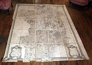
SEGUIN, Jean-Dominique - CASSINI DE THURY, Cesar-Francois (1714-1784) - CAMUS, Charles Etienne Louis Camus (1699 1768) - MONTIGNY, Etienne Mignot de (1714 1782). Carte Particulière du Duché de Bourgogne Levée Géométriquement Par Ordre de M.M. les Elus Généraux de la Province, en conséquence du Décret des Etats de 1751, divisée par Diocèses, Bailliages et Subdélégations, Faisant partie de la Carte Générale de la France, levée par Ordre du Roy et par les Ingénieurs Géographes de Sa Majesté sous la direction de M.rs. Cassini, Camus et de Montigny de l'Académie R.le. des Sciences dressée et exécutée par le Sr. Séguin, Ing.r Geog.phe du Roy en 1763. 10 double-page, and 5 full-page engraved map sheets, together creating a large map of Burgundy (overall size 116 x 99 inches, each sheet with full margins, showing the plate mark). A MAGNIFICENT and very detailed map of Burgundy engraved by Bourgoign le Jeune after Seguin and Cassini, showing the region divided into dioceses, bailiwicks and sub-delegations, all routes, waterways, cities, towns, villages, forests and fields, and all surrounded by a handsome and broad border with large acanthus leaves at each corner and surmounted by a large sun and cloud burst containing the arms of France, with three magnificent, detailed rococo allegorical cartouches containing the legend, the title, and a vignette of the city of Dijon, designed by Galey (some minor browning to one or two sheets). In 1747 King Louis XV of France (1710-1774), known as Louis the Beloved (Louis le bien aimé), of the House of Bourbon, commissioned César-François Cassini de Thury (Cassini III 1714-1784) to create a complete survey of France, the "Carte de France". This was a huge undertaking, initially funded by the crown, until 1756, subsequently until 1762 by a company of shareholders, and thereafter by the individual provinces of France. Burgundy was one of the first provinces to provide funding for the survey of their region. Of the resulting 180 map sheets of France, 12 created between 1752 and 1762 covered the area of Burgundy, and were used to create this astonishing and first stand-alone regional map of the project. Other regions followed suite, creating a series of maps more decorative and majestic in appearance than those directly published for Cassini's "Carte de France". Cassini's mammoth map of France was the first complete national map constructed on modern principles of surveying and astronomy. As such, historian Josef Konvitz considers it nothing less than a "monument to the taste and intelligence of the French Enlightenment." The ambitious project, which was jointly managed with Cassini de Thury's son, Jacques-Dominique, ultimately took nearly seven decades to complete and required the efforts of more than eighty individuals. "By 1760, 50 maps of the 180 projected were finished, all in the north-central part of France. Between 1760 and 1770, 38 were published, covering all of eastern France, central France north of Lyon, and western France east of Rennes and north of Poitiers. Forty-five more were available by 1780, covering Anjou, Poitou, the Dauphin, and Provence. The Limousin, the Pyrenees frontier, and the region of Nice appeared between 1780 and 1789. All fieldwork but not all engraving was completed by 1789." (Konvitz, Cartography in France 1660-1848. Chicago, 1987, pp. 21-25). Cassini de Thurry and Jean-Dominique's project was largely completed by the beginning of the French Revolution. Though their venture had been initially funded by the French government, Cassini de Thury had later decided to finance the project through the selling of shares to nobles, officials, and other leading members of society like Louis XV's mistress, Madame de Pompadour. In 1793 the revolutionary government expropriated the Cassini's maps, as they were of great military value. The Revolutionary government at that time also proceeded to dissolve Cassini de Thury's company and to execute its fo. N° de ref. del artículo 72map315
Contactar al vendedor
Denunciar este artículo
![]()
