Descripción
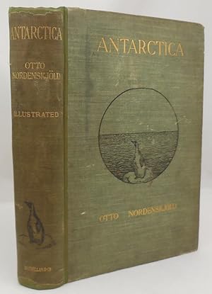
Book condition: very good, very scarce, over 200 wonderful b/w and color illustrations along with four color maps, three are fold out and all are in excellent condition, one map is the northern part of the mainland and islands of West Antarctica, another shows the track of Antarctic within the South Polar regions and the neighboring seas, green cloth boards feature an illustration of a penguin on an ice floe and show moderate soling to upper left front, light soiling to other areas, a few white scuffs to front, gilt bright and intact on front and spine which is darkened and shows a penguin illustration, the boards and spine have been recased with the original spine kept, previous owner's name and address stamp on ffep and bottom margin of page 175, outside corners of ffep clipped, water stain to upper outside corner of first 24 pages plus illustration, small pencil mark at bottom of page 608 otherwise interior very clean, binding firm, 608 pages with index, 6.5 X 9.25 inches. Postage for oversized and international shipping will be calculated by size and weight. AbeBooks shipping quotes are ESTIMATES only. If actual shipping cost is less than the AbeBooks estimate, it is our practice to REFUND the difference to the buyer. N° de ref. del artículo 007843
Contactar al vendedor
Denunciar este artículo
![]()


