Importe total (1 artículo artículos):
Destino del pedido:

dartmouth de ordnance survey (12 resultados)
Ir a los resultados principales
Tipo de artículo
- Todo tipo de artículos
- Libros (6)
- Revistas y publicaciones
- Cómics
- Partituras
- Arte, grabados y pósters
- Fotografías
- Mapas (6)
-
Manuscritos y
coleccionismo de papel
Condición
- Todo
- Nuevos
- Antiguos o usados
Encuadernación
Más atributos
- Primera edición
- Firmado
- Sobrecubierta
- Con imágenes del vendedor (7)
- Sin impresión bajo demanda
Ubicación del vendedor
Valoración de los vendedores
-
Reprint of the First Edition of the One-inch Ordnance Survey of England and Wales: Sheet Number 91: Exeter and Dartmouth
Publicado por David & Charles, Newton Abbot, 1969
ISBN 10: 0715344129ISBN 13: 9780715344125
Librería: Victoria Bookshop, BERE ALSTON, DEVON, Reino Unido
Valoración del vendedor:

Libro
Paperback. Condición: Good. Reprint. Ex Dartington Hall Library. Book.
Más opciones de compra de otros vendedores en IberLibro
Usado desde EUR 5,92
-

Reprint of the First Edition of the One-inch Ordnance Survey of England and Wales: Sheet Number 91: Exeter and Dartmouth
Publicado por David & Charles, London, 1968
Librería: Victoria Bookshop, BERE ALSTON, DEVON, Reino Unido
Valoración del vendedor:
Paperback. Condición: Good. First Thus. 8vo. A good copy with some minor scuffing to cover edges, a couple of nicks and minor creases and Dartington Library stamp on front. Map in good condition. Book.
-
Condición: Good. This is an ex-library book and may have the usual library/used-book markings inside.This book has soft covers. In good all round condition. Undated Please note the Image in this listing is a stock photo and may not match the covers of the actual item,150grams, ISBN:
-
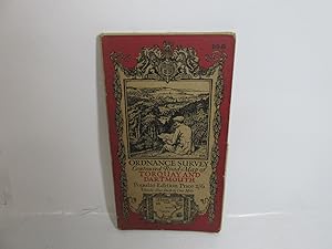
Ordnance Survey One-Inch Map. Torquay and Dartmouth. Popular Edition. Sheet 145. Scale: One Inch to to One Mile. BRIGHT, CLEAN COPY
Publicado por Ordnance Survey, Southampton, [1931], 1931
Librería: Island Books, Thakeham, West Sussex, Reino Unido
Valoración del vendedor:
Mapa
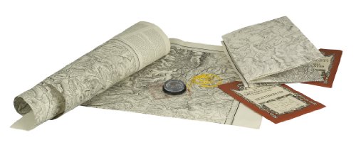
Folding coloured map on cloth measuring 22 x 30 ins (approx. 56 x 76 cms) folding in 21 panels to 7.0 x 4.0 ins (approx. 17.7 x 10.1 cms); original pictorial card wrappers, WANTING LOWER WRAPPER else a very good, bright, clean copy. The famous Popular Edition One Inch series with striking 'cyclist' artwork by Ellis Martin was issued in 1919. This is the 1931 reissue (roads revised to 1925). The covers are black with red sheet name and location map. Browne, 11.1.a.
-
Ordnance Survey Contoured Road Map of Torquay & Dartmouth, 1919, cloth
Librería: Devils in the Detail Ltd, Oxford, Reino Unido
Valoración del vendedor:
Condición: Good. Ordnance Survey Contoured Road Map of Torquay & Dartmouth, 1919, clothSize: 61cm x 57cm approx when opened.Condition: Some minor foxing/folds. A nice item for age.
-
![Imagen del vendedor de Ordnance Survey Contoured Road Map [One-inch Popular Edition], sheet 145, Torquay and Dartmouth. a la venta por Cornell Books Limited](https://pictures.abebooks.com/inventory/md/md31090632374.jpg)
Ordnance Survey Contoured Road Map [One-inch Popular Edition], sheet 145, Torquay and Dartmouth.
Publicado por Southampton: Ordnance Survey, 1934., 1934
Librería: Cornell Books Limited, Tewkesbury, Reino Unido
Miembro de asociación: PBFA
Valoración del vendedor:
Mapa
First printed in 1919, this is a reprint from 1934 (print code 3500/34). Mounted on cloth and folded in the original covers, with a front cover illustration by Ellis Martin. The map is in very good condition; the covers are in near-VG condition (lightly rubbed). Also covers Paignton, Brixham, Totnes, Buckfastleigh, East Brent, Modbury, Kingsbridge and Salcombe.
-
Reprint of the First Edition of the One-inch Ordnance Survey of England and Wales: Sheet Number 91: Exeter and Dartmouth
Publicado por David and Charles, 1983
Paper Back. Condición: Very Good. Very good coy in a VG slipcase.
-
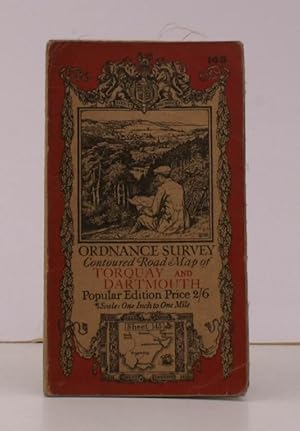
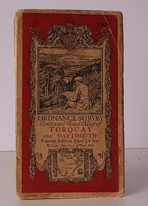
Ordnance Survey Contoured Road Map of Torquay and Dartmouth. Sheet 145. Popular Edition. Scale: One Inch to to One Mile. GOOD, FIRM COPY
Publicado por Ordnance Survey, Southampton, [1926], 1926
Librería: Island Books, Thakeham, West Sussex, Reino Unido
Valoración del vendedor:
Mapa
Folding coloured map on cloth measuring 21 x 30 ins (approx. 53.0 x 76.0 cms) folding in 24 panels to 7.0 x 4.0 ins (approx. 17.7 x 10.1 cms); original pictorial card wrappers, light wear to folds else a bright, clean copy. The famous Popular Edition One Inch series with striking 'cyclist' artwork by Ellis Martin was first issued in 1919. This is the 1926 revision. The covers are black with red sheet name and location map. Browne, 11.1.a.
-
![Imagen del vendedor de Ordnance Survey Contoured Road Map of Torquay and Dartmouth. Popular Edition. One Inch. Sheet 145. [Ellis Martin cover]. a la venta por Island Books](https://pictures.abebooks.com/inventory/md/md13161590299.jpg)
Ordnance Survey Contoured Road Map of Torquay and Dartmouth. Popular Edition. One Inch. Sheet 145. [Ellis Martin cover].
Publicado por Ordnance Survey, [Southampton,, 1925
Librería: Island Books, Thakeham, West Sussex, Reino Unido
Valoración del vendedor:
Mapa
Folding coloured map on cloth measuring 22.0 x 28.5 ins (approx. 56.0 x 72.0 cms) folding in 21 panels to 7.5 x 4.25 ins (approx. 19.0 x 11.0 cms), covers lightly dust-soiled else a very good, bright, clean copy. The famous Popular Edition One Inch series was first published in 1919 with striking 'hiker' artwork by Ellis Martin. The present copy is the 1925 revision; the covers are the dark red and black variant with location map. Browne, 11.2.a.
-
![Imagen del vendedor de Ordnance Survey sheet 23 [Dartmouth, Brixham, Slapton, Start Point - South Devon] a la venta por Antiqua Print Gallery](https://pictures.abebooks.com/inventory/md/md31583241167.jpg)
Ordnance Survey sheet 23 [Dartmouth, Brixham, Slapton, Start Point - South Devon]
Ańo de publicación: 1809
Mapa
Condición: Good. Ordnance Survey #23 Start Bay & Dartmouth. Brixham Slapton South Devon 1809 map. Antique folding hand coloured survey map, dissected and laid down on linen; Engraved at the Ordnance Map Office, Tower of London. Engraved by Benjamin Baker and assistants. Writing by Ebenezer Bourne. Published by William Mudge. (1809). 66.0 x 97.5cm, 26 x 38.5 inches; this is a folding map. Condition: Good. There is nothing printed on the reverse side, which is plain. The genesis of the Ordnance Survey's original one-inch per mile survey occurred in 1783 when the Royal Societies of Paris and London agreed to connect their two great cities by the use of triangulation to settle the dispute of their relative positions. This triangulation, completed by 1790, together with the outbreak of war with France in 1793, acted as a catalyst for the surveying of England. The survey began in Kent and by the end of the Napoleonic Wars in 1815 most of southern England had been mapped. By 1844, publication of the Old Series, one inch to one mile, was complete for the whole of Great Britain south of Preston and Hull. In spite of concerns about the cost of the survey, work continued until by 1870 the whole of England and Wales had been mapped.