
Importe total (1 artículo artículos):
Destino del pedido:

contoured road map dukeries (4 resultados)
Ir a los resultados principales
Tipo de artículo
- Todo tipo de artículos
- Libros (2)
- Revistas y publicaciones
- Cómics
- Partituras
- Arte, grabados y pósters
- Fotografías
- Mapas (2)
-
Manuscritos y
coleccionismo de papel
Condición
- Todo
- Nuevos
- Antiguos o usados
Encuadernación
Más atributos
- Primera edición
- Firmado
- Sobrecubierta
- Con imágenes del vendedor (3)
- Sin impresión bajo demanda
Ubicación del vendedor
Valoración de los vendedores
-
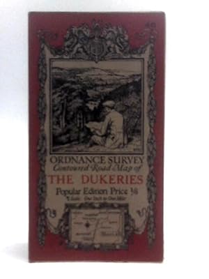
Ordnance Survey Contoured Road Map, Sheet 46, The Dukeries.
Publicado por Ordnance Survey, 1923
Librería: World of Rare Books, Goring-by-Sea, SXW, Reino Unido
Valoración del vendedor:

Condición: Fair. 1923. Popular Edition. Unpaginated. Card covers over paper map. Pages are clean but there are several splits between panels. Card covers are clean if a little rubbed. Pencil marks to the rear panel.
-
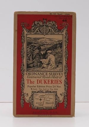
Ordnance Survey Contoured Road Map of The Dukeries. Popular Edition. Sheet 46 Scale: One Inch to One Mile. BRIGHT, CLEAN COPY
Publicado por Ordnance Survey, Southampton, [1932], 1932
Librería: Island Books, Thakeham, West Sussex, Reino Unido
Valoración del vendedor:
Mapa
Folding coloured map on cloth measuring 22 x 29 ins (approx. 59 x 74 cms) folding in 21 panels to 7.0 x 4.5 ins (approx. 17.7 x 10.5 cms), small signature and stamp on front wrapper; original pictorial card wrappers, a very good, bright, clean copy First issued in 1923. This is the 1932 reissue. The cover is Ellis Martin's 'cyclist on hillside' in dark red and black with location map. Browne, 11.2.a.
-

O/S CONTOURED ROAD MAP OF 'THE DUKERIES'
Publicado por 1923, 1923
Librería: Black Cat Bookshop P.B.F.A, Leicester, Reino Unido
Miembro de asociación: PBFA
Valoración del vendedor:

O/S contoured road map of 'the Dukeries'. One inch to one mile. Popular edition 1923. Including Mansfield, East Retford, Worksop etc. Sheet 46. VG.
-
![Imagen del vendedor de Ordnance Survey Contoured Road Map [One-inch Popular Edition], sheet 46, The Dukeries. a la venta por Cornell Books Limited](https://pictures.abebooks.com/inventory/md/md31088189602.jpg)
Ordnance Survey Contoured Road Map [One-inch Popular Edition], sheet 46, The Dukeries.
Publicado por Southampton: Ordnance Survey, 1936., 1936
Librería: Cornell Books Limited, Tewkesbury, Reino Unido
Miembro de asociación: PBFA
Valoración del vendedor:
Mapa
First published in 1923, this copy is a reprint from 1936 (print code 3036). Mounted on cloth and folded in the original covers, with a front cover illustration by Ellis Martin. The map and the covers are in very good condition. Covers Mansfield, Sutton in Ashfield, Clowne, Worksop, East Retford, Tuxford and Ollerton, and Newark upon Trent appears in the lower (southern) margin.
