Importe total (1 artículo artículos):
Destino del pedido:

wilkes charles 1798 1877 (40 resultados)
Ir a los resultados principales
Tipo de artículo
- Todo tipo de artículos
- Libros (40)
- Revistas y publicaciones
- Cómics
- Partituras
- Arte, grabados y pósters
- Fotografías
- Mapas
-
Manuscritos y
coleccionismo de papel
Condición
Encuadernación
Más atributos
- Primera edición (5)
- Firmado (1)
- Sobrecubierta
- Con imágenes del vendedor (10)
- Sin impresión bajo demanda (31)
Gastos de envío gratis
Ubicación del vendedor
Valoración de los vendedores
-

Memoir on the Trent Affair
Publicado por Legare Street Press, 2021
ISBN 10: 101444263XISBN 13: 9781014442635
Librería: Lucky's Textbooks, Dallas, TX, Estados Unidos de America
Valoración del vendedor:

Libro
Condición: New.
-
Synopsis of the Cruise of the U.S. Exploring Expedition, During the Years 1838, '39, '40, '41 & '42: Delivered Before the National Institute by Its . to Which is Added a List of Officers And.
Publicado por Legare Street Press, 2021
ISBN 10: 1014044634ISBN 13: 9781014044631
Librería: Lucky's Textbooks, Dallas, TX, Estados Unidos de America
Valoración del vendedor:
Libro
Condición: New.
Más opciones de compra de otros vendedores en IberLibro
Nuevo desde EUR 16,07
-
![Imagen de archivo de Synopsis of the Cruise of the U.S. Exploring Expedition During the Years 1838, '39, '40, '41, & '42 [microform]: to Which is Added a List of Officers and Scientific Corps Attached to the Expedition a la venta por Lucky's Textbooks](https://pictures.abebooks.com/isbn/9781014723734-es-300.jpg)
Synopsis of the Cruise of the U.S. Exploring Expedition During the Years 1838, '39, '40, '41, & '42 [microform]: to Which is Added a List of Officers and Scientific Corps Attached to the Expedition
Publicado por Legare Street Press, 2021
ISBN 10: 1014723736ISBN 13: 9781014723734
Librería: Lucky's Textbooks, Dallas, TX, Estados Unidos de America
Valoración del vendedor:
Libro
Condición: New.
Más opciones de compra de otros vendedores en IberLibro
Nuevo desde EUR 16,07
-

Narrative of the United States Exploring Expedition: During the Years 1838, 1839, 1840, 1841, 1842; v. 2
Publicado por Legare Street Press, 2023
ISBN 10: 1022432362ISBN 13: 9781022432369
Librería: GreatBookPrices, Columbia, MD, Estados Unidos de America
Valoración del vendedor:
Libro
Condición: New.
Más opciones de compra de otros vendedores en IberLibro
Nuevo desde EUR 33,07
Usado desde EUR 34,22
Encuentre también Tapa blanda
-

Narrative of the United States' Exploring Expedition, During the Years 1838, 1839, 1840, 1841, 1842. Condensed and Abridged
Publicado por Legare Street Press 2021-09-10, 2021
ISBN 10: 1015355293ISBN 13: 9781015355293
Libro
Paperback. Condición: New.
Más opciones de compra de otros vendedores en IberLibro
Nuevo desde EUR 21,65
-
Narrative of the United States Exploring Expedition, During the Years 1838, 1839, 1840, 1841, 1842; Volume 3
Publicado por Legare Street Press 2022-10, 2022
ISBN 10: 1017860467ISBN 13: 9781017860467
Libro
PF. Condición: New.
Más opciones de compra de otros vendedores en IberLibro
Nuevo desde EUR 25,35
-

Narrative of the United States Exploring Expedition, During the Years 1838, 1839, 1840, 1841, 1842; Volume 3
Publicado por Legare Street Press, 2022
ISBN 10: 1017855404ISBN 13: 9781017855401
Librería: THE SAINT BOOKSTORE, Southport, Reino Unido
Valoración del vendedor:
Libro Impresión bajo demanda
Hardback. Condición: New. This item is printed on demand. New copy - Usually dispatched within 5-9 working days.
-

US EXPLORING EXPEDITION DURING
Publicado por WENTWORTH PR, 2016
ISBN 10: 1371900027ISBN 13: 9781371900021
Libro
Condición: New.
-

US EXPLORING EXPEDITION DURING
Publicado por WENTWORTH PR, 2016
ISBN 10: 1371184925ISBN 13: 9781371184926
Libro
Gebunden. Condición: New.
-

US EXPLORING EXPEDITION DURING
Publicado por WENTWORTH PR, 2016
ISBN 10: 1371185263ISBN 13: 9781371185268
Libro
Gebunden. Condición: New.
-

Narrative of the United States exploring expedition during the years 1838, 1839, 1840, 1841, 1842 - vol. 1
Publicado por Philadelphia : Lea & Blanchard, 1845
Original o primera edición
First Edition. Poor copy, wear and tear as with age. Boards detached. Text remains in fine condition. Physical description; 1 v. : fronts., ill., plates. Subjects; Wilkes, Charles 1798-1877 Travel. United States Exploring Expedition (1838-1842). Discoveries in geography. Scientific expeditions. 3 Kg.
-

Narrative of the United States exploring expedition during the years 1838, 1839, 1840, 1841, 1842 - vol. 1
Publicado por Philadelphia : Lea & Blanchard, 1845
Librería: MW Books, New York, NY, Estados Unidos de America
Valoración del vendedor:
Original o primera edición
First Edition. Poor copy, wear and tear as with age. Boards detached. Text remains in fine condition. Physical description; 1 v. : fronts., ill., plates. Subjects; Wilkes, Charles 1798-1877 Travel. United States Exploring Expedition (1838-1842). Discoveries in geography. Scientific expeditions. 3 Kg.
-
NARRATIVE OF THE UNITED STATES EXPEDITION DURING THE YEARS 1838, 1839, 1840, 1841, 1842 - 5 vol. set
Publicado por G P Putnam & Co., NY, 1856
Librería: Terra Firma Books, San Diego, CA, Estados Unidos de America
Valoración del vendedor:

Libro
Hardcover. Condición: Good. 5 vol. set in original brown cloth embossed decorative bindings. Complete with 13 maps and numerous engravings. Provenance: Sigma Pi Society otherwise Clean.
-
Narrative of the United States Exploring Expedition. During the Years 1868, 1839, 1840, 1841, 1842. Five [5] Volumes
Publicado por Lea & Blanchard, Philadelphia, 1845
Librería: Resource Books, LLC, East Granby, CT, Estados Unidos de America
Miembro de asociación: SNEAB
Valoración del vendedor:
Original o primera edición
Hardcover. Condición: Good. Philadelphia: Lea & Blanchard, 1845. First edition available to the public, 1845. Five volumes, lacks the atlas. Publisher's original cloth, five imposing volumes with page size approximately 11" x 7", some volumes with a large number of unopened page edges. Includes all the steel plate engravings and maps called for in the five volumes of text, half-titles included in each volume. Dark brown cloth with gilt spine lettering and gilt vignettes of eagle, shield and ship on covers and woman with map and ship on spine, additional cover decoration in blind, edges untrimmed. Good to very good condition with expected rubbing to covers, some spine chipping and wearthrough to corners, good hinges sound text blocks, lightly age-toned but clean pages with some occasional light foxing, modest semi-circular transparent stains to far outer margins of a few plates (images not affected), top margins of last 50 or so pages in volume III have transparent tide marks that do not affect printed areas, New South Wales map in volume II bound in upside down. No ownership names or markings. Important account of expedition which circumnavigated the globe and included Antarctica, Pacific islands and the western coast of North America. Hard Cover. Good. 4to - over 9Âľ" - 12" tall.
-
Atlas to accompany "Narrative of the United States Exploring Expedition. During the years 1838, 1839, 1840, 1841, 1842".
Publicado por Philadelphia: Lea and Blanchard, 1845., 1845
Librería: Arader Galleries - AraderNYC, New York, NY, Estados Unidos de America
Valoración del vendedor:
"WILKES, Charles (1798-1877). Atlas to accompany "Narrative of the United States Exploring Expedition. During the years 1838, 1839, 1840, 1841, 1842". Philadelphia: Lea and Blanchard, 1845. Imperial 8vo., (11 x 7 inches). Letterpress title-page, contents leaf. 5 large folding lithographed maps on bank note paper, the "Chart of the World " with contemporary hand-color (few separations at folds, browned, one or two marginal stains). Original brown publisher's cloth, gilt (a bit scuffed at the head and foot of the spine). "THE UNITED STATES EQUIVALENT TO THE VOYAGES OF JAMES COOK, JEAN FRANCOIS GALAUP DE LAPEROUSE, ALEJANDRO MALASPINA, AND IVAN FEDOROVICH KRUZENSHTERN FOR ENGLAND, FRANCE, SPAIN, AND RUSSIA, AND THE MARITIME EQUIVALENT OF LEWIS AND CLARK" (W. Michael Mathes). Atlas to accompany the third issue overall preceded by a very rare quarto edition of about 100 copies (of which 25 were destroyed by fire) published in 1844, and a limited issue of 150 copies for private distribution. This atlas is limited to 1000 copies, see Haskell 16B. These large maps are: "Chart of the World Shewing the Tracks of the U.S. Exploring Expedition in 1838, 39, 40, 41 & 42. Charles Wilkes Esq. Commander", engraved by Sherman & Smith N.Y. A fine map following Mercator's projection, showing winds and currents, the tracks of the ships Vincennes, Peacock, Porpoise, Flying Fish, Oregon, and Relief (tape repairs to verso). "Chart of the Antarctic Continent Shewing the Icy Barrier Attached to it. Discovered by the U.S. Ex. Ex. Charles Wilkes. Esq, Commander 1840" Engraved by Sherman & Smith, N.Y. A fine map with Victoria (Australia) and Van Dieman's Land shaded in, showing the tracks of the ships Vincennes, Peacock, Porpoise, and Flying Fish along the coast of Antarctica, with five profile views of the Antarctic continent (one or two small holes at folds). "Chart of the Viti Group or Feejee Islands by the U.S. Ex. Ex. Charles Wilkes Esq. Commander 1840", engraved by Sherman & Smith, N.Y. A very detailed chart of the islands. "Map of the Oregon Territory by the U.S. Ex. Ex. Charles Wilkes Esqr. Commander. 1841", engraved by J. H. Young & Sherman & Smith, N.Y. A magnificent map (reduced in size for the later editions) with an inset of the "Columbia River Reduced from a Survey Made by the U.S. Ex. Ex. 1841" showing the area of Oregon Territory as claimed by the United States, extending well north of Vancouver, west from the Black Hills, north to just above the fifty-third parallel, and south to Cape Mendocino. This is the "first official [U.S.] chart of any portion of the West Coast and covers the coast from Cape Mendocino to Queen Charlotte Islands. The inset of the Columbia River includes geography extending as far as Walla Walla. It is a handsome map printed on imported paper from copperplates purchased in France from the Depot de la Marine. The engravers themselves were European craftsmen who not only executed the work, but also trained the American apprentices, including the artist James McNeill Whistler, who served as an engraver on the Coast Survey and learned his craft from those who engraved the Wilkes charts" (Cohen, Mapping the West, pp. 120-122). "Map of Part of the Island of Hawaii Sandwich Islands Shewing the Craters and Eruption of May and June 1840. By the U.S. Ex. Ex. 1841", engraved by Sherman & Smith, Sc. N.Y. Showing the area from Hilo to the top of Mauna Loa. Wilke's celebrated circumnavigation explored extensively the coast of South America, the South Seas, Antarctica, California and the Northwest. Departing in August 1838, Wilkes rounded Cape Horn; crossed the Pacific surveying, charting, and exploring the Tuamotus, Tahiti, and Samoa; and reached Sydney, Australia, in November 1839. His ships probed Antarctic waters, cruising 1,500 miles along an unbroken ice shelf; then sailed via New Zealand and Tonga, reaching Fiji in May 1840. In September 1840 Wilkes reached Hawaii, and arrived off the Oregon coast in April 1841, "Wilkes foun.
-
Narrative of the United States Exploring Expedition. During the Years 1838, 1839, 1840, 1841, 1842
Publicado por Lea and Blanchard, Philadelphia, 1845
Librería: The Book Collector, Inc. ABAA, ILAB, Fort Worth, TX, Estados Unidos de America
Miembro de asociación: ABAA ILAB IOBA
Valoración del vendedor:
Libro
Hardcover. Condición: Very Good. 3rd Edition. 6 volumes. lx+434 pages with frontispiece, 7 plates, 15 vignettes (including music scores), 67 woodcuts, tables and one internal folding map; xvi+476 pages with frontispiece, 13 plates, 14 vignettes (including music scores), 46 woodcuts, and 3 folding maps; xv+438 pages with 12 plates, 10 vignettes (including music scores) and 50 woodcuts; xv+539 pages with fold out frontispiece map, 15 plates, tables, 5 vignettes and 35 woodcuts; xii+558 pages with frontispiece fold out map, 15 plates, 3 vignettes, 49 woodcuts, tables, 3 maps and index; atlas 5 engraved folding maps and charts (one hand-colored) Quarto (10 3/4" x 7") bound in uniform half-blue calf over marbled boards, cornered in calf (Cowan p.683; Forbes 1574; Hill 1867; Haskell 2B, 17; Howes W-414; Rosove 353.B1) The first edition published by Sherman in 1844 of which 100 copies were printed for sale and 63 sets which were given to states and foreign nations and which 25 were destroyed in a fire. An unofficial edition by Lea And Blanchard in 1845 which was the same size and collation except for added half title in Atlas and limited to 150 sets. This the first available edition was limited to 1000 copies. Later octavo editions omitted the Atlas. In 1838, although not yet a seasoned naval line officer, Wilkes was experienced in nautical survey work, and was working with civilian scientists. Upon this background, he was given command of the government exploring expedition ". for the purpose of exploring and surveying the Southern Ocean, . . . as well to determine the existence of all doubtful islands and shoals, as to discover, and accurately fix, the position of those which [lay] in or near the track of our vessels in that quarter, and [might] have escaped the observation of scientific navigators." The U.S. Exploring Squadron was authorized by act of the Congress on May 18, 1836. The United States Exploring Expedition, commonly known as the Wilkes Expedition, included naturalists, botanists, a mineralogist, taxidermists, artists and a philologist, and was carried by the USS Vincennes (780 tons) and Peacock (650 tons), the brig Porpoise (230 tons), the store-ship Relief, and two schooners, Sea Gull (110 tons) and Flying Fish (96 tons). Departing from Hampton Roads on August 18, 1838, the expedition stopped at the Madeira Islands and Rio de Janeiro, Argentina; visited Tierra del Fuego, Chile, Peru, the Tuamotu Archipelago, Samoa, and New South Wales; from Sydney, Australia sailed into the Antarctic Ocean in December 1839 and reported the discovery "of an Antarctic continent west of the Balleny Islands". next, the expedition visited Fiji and the Hawaiian Islands in 1840, explored the west coast of the United States, including the Strait of Juan de Fuca, Puget Sound, the Columbia River, San Francisco Bay and the Sacramento River, in 1841, and returned by way of the Philippines, the Sulu Archipelago, Borneo, Singapore, Polynesia and the Cape of Good Hope, reaching New York on June 10, 1842. In July 1840, two sailors, one of whom was Wilkes' nephew, Midshipman Wilkes Henry, were killed while bartering for food on Fiji's Malolo Island. Wilkes retribution was swift and severe. According to an old man of Malolo Island, nearly 80 Fijians were killed in the incident. From December 1840 to March 1841, he employed hundreds of Hawaiian porters and many of his men to haul a pendulum to the summit of Mauna Loa to measure gravity. Instead of using the existing trail, he blazed his own way, taking much longer than he anticipated. The conditions on the mountain reminded him of Antarctica. Many of his crew suffered snow blindness, altitude sickness and foot injuries from wearing out their shoes. After having completely encircled the globe (his was the last all-sail naval mission to do so), Wilkes had logged some 87,000 miles and lost two ships and 28 men. Wilkes was court-martialed upon his return for the loss of one of his ships on the Columbia River bar, for the regular mistreatment.
-
Narrative of the United States Exploring Expedition. During the Years 1838, 1839, 1840, 1841, 1842.
Publicado por Philadelphia: Lea & Blanchard, 1845., 1845
Librería: Arader Galleries - AraderNYC, New York, NY, Estados Unidos de America
Valoración del vendedor:
Original o primera edición Ejemplar firmado
5 text volumes and 1 atlas volume. Imperial 8vo., signed in 4's, (11 ˝ x 7 ľ inches). Half titles. 5 fine folding lithographed maps on banknote paper, one with original hand color (some separation along folds, one or two short marginal tears, some browning and offsetting); frontispiece maps in volumes IV and V, 7 double-page engraved maps, engraved frontispieces, 61 engraved plates, numerous in-text illustrations (pale staining to upper margin of a few plates). Original brown publisher's cloth, decorated in blind and lettered in gilt, the smooth spines with gilt vignettes (rebacked to style, preserving most of the original spines, a few pale stains). Provenance: Christie's Sale 1820: The Frank S. Streeter Library: Important Navigation, Pacific Voyages, Cartography, Science; 16 - 17 April 2007. First trade edition. "THE UNITED STATES EQUIVALENT TO THE VOYAGES OF JAMES COOK, JEAN FRANCOIS GALAUP DE LAPEROUSE, ALEJANDRO MALASPINA, AND IVAN FEDOROVICH KRUZENSHTERN FOR ENGLAND, FRANCE, SPAIN, AND RUSSIA, AND THE MARITIME EQUIVALENT OF LEWIS AND CLARK" (W. Michael Mathes). The third overall edition: Haskell's "unofficial issue" 2B, limited to 1,000 copies. Preceded only by the official government edition, published in 1844 and limited to 100 copies, and the unofficial edition, published by Lea and Blanchard in 1845 and limited to 150 copies. The large maps in the atlas are: "Chart of the World Shewing the Tracks of the U.S. Exploring Expedition in 1838, 39, 40, 41 & 42. Charles Wilkes Esq. Commander," engraved by Sherman & Smith N.Y. A fine map following Mercator's projection, showing winds and currents, the tracks of the ships Vincennes, Peacock, Porpoise, Flying Fish, Oregon, and Relief. "Chart of the Antarctic Continent Shewing the Icy Barrier Attached to it. Discovered by the U.S. Ex. Ex. Charles Wilkes. Esq, Commander 1840," engraved by Sherman & Smith, N.Y. A fine map with Victoria (Australia) and Van Dieman's Land shaded in, showing the tracks of the ships Vincennes, Peacock, Porpoise, and Flying Fish along the coast of Antarctica, with five profile views of the Antarctic continent. "Chart of the Viti Group or Feejee Islands by the U.S. Ex. Ex. Charles Wilkes Esq. Commander 1840," engraved by Sherman & Smith, N.Y. A very detailed chart of the islands. "Map of the Oregon Territory by the U.S. Ex. Ex. Charles Wilkes Esqr. Commander. 1841," engraved by J. H. Young & Sherman & Smith, N.Y. A magnificent map (reduced in size for the later editions) with an inset of the "Columbia River Reduced from a Survey Made by the U.S. Ex. Ex. 1841" showing the area of Oregon Territory as claimed by the United States, extending well north of Vancouver, west from the Black Hills, north to just above the fifty-third parallel, and south to Cape Mendocino. This is the "first official [U.S.] chart of any portion of the West Coast and covers the coast from Cape Mendocino to Queen Charlotte Islands. The inset of the Columbia River includes geography extending as far as Walla Walla. It is a handsome map printed on imported paper from copperplates purchased in France from the Depot de la Marine. The engravers themselves were European craftsmen who not only executed the work, but also trained the American apprentices, including the artist James McNeill Whistler, who served as an engraver on the Coast Survey and learned his craft from those who engraved the Wilkes charts" (Cohen, Mapping the West, pp. 120-122). "Map of Part of the Island of Hawaii Sandwich Islands Shewing the Craters and Eruption of May and June 1840. By the U.S. Ex. Ex. 1841," engraved by Sherman & Smith, Sc. N.Y. Showing the area from Hilo to the top of Mauna Loa. Wilke's celebrated circumnavigation explored extensively the coast of South America, the South Seas, Antarctica, California and the Northwest. Departing in August 1838, Wilkes rounded Cape Horn; crossed the Pacific surveying, charting, and exploring the Tuamotus, Tahiti, and Samoa; and reached Sydney, Australia, in November.
-

Narrative of the United States Exploring Expedition.
Publicado por Philadelphia: Lea and Blanchard, 1845., 1845
Librería: Arader Galleries - AraderNYC, New York, NY, Estados Unidos de America
Valoración del vendedor:
Original o primera edición
6 volumes. 5 text volumes. Imperial 8vo., (11 x 7 inches). Half-titles. 5 large folding maps on Japan paper in atlas (1 hand-colored), 9 double-page maps in text volumes, engraved frontispiece portrait of Wilkes, 63 engraved plates, and numerous engravings and vignettes throughout (one or two marginal tears, some spotting throughout). Original brown publisher's cloth, gilt (rubbed and slightly worn). Provenance: With bookplates and ink library stamps of the New Jersey Historical Society. Swann sale 1843, December 1999, Lot 428. First trade edition. "THE UNITED STATES EQUIVALENT TO THE VOYAGES OF JAMES COOK, JEAN FRANCOIS GALAUP DE LAPEROUSE, ALEJANDRO MALASPINA, AND IVAN FEDOROVICH KRUZENSHTERN FOR ENGLAND, FRANCE, SPAIN, AND RUSSIA, AND THE MARITIME EQUIVALENT OF LEWIS AND CLARK" (W. Michael Mathes). The third overall edition: Haskell's "unofficial issue" 2B, limited to 1,000 copies. Preceded only by the official government edition, published in 1844 and limited to 100 copies, and the unofficial edition, published by Lea and Blanchard in 1845 and limited to 150 copies. The large maps in the atlas are: "Chart of the World Shewing the Tracks of the U.S. Exploring Expedition in 1838, 39, 40, 41 & 42. Charles Wilkes Esq. Commander," engraved by Sherman & Smith N.Y. A fine map following Mercator's projection, showing winds and currents, the tracks of the ships Vincennes, Peacock, Porpoise, Flying Fish, Oregon, and Relief. "Chart of the Antarctic Continent Shewing the Icy Barrier Attached to it. Discovered by the U.S. Ex. Ex. Charles Wilkes. Esq, Commander 1840," engraved by Sherman & Smith, N.Y. A fine map with Victoria (Australia) and Van Dieman's Land shaded in, showing the tracks of the ships Vincennes, Peacock, Porpoise, and Flying Fish along the coast of Antarctica, with five profile views of the Antarctic continent. "Chart of the Viti Group or Feejee Islands by the U.S. Ex. Ex. Charles Wilkes Esq. Commander 1840," engraved by Sherman & Smith, N.Y. A very detailed chart of the islands. "Map of the Oregon Territory by the U.S. Ex. Ex. Charles Wilkes Esqr. Commander. 1841," engraved by J. H. Young & Sherman & Smith, N.Y. A magnificent map (reduced in size for the later editions) with an inset of the "Columbia River Reduced from a Survey Made by the U.S. Ex. Ex. 1841" showing the area of Oregon Territory as claimed by the United States, extending well north of Vancouver, west from the Black Hills, north to just above the fifty-third parallel, and south to Cape Mendocino. This is the "first official [U.S.] chart of any portion of the West Coast and covers the coast from Cape Mendocino to Queen Charlotte Islands. The inset of the Columbia River includes geography extending as far as Walla Walla. It is a handsome map printed on imported paper from copperplates purchased in France from the Depot de la Marine. The engravers themselves were European craftsmen who not only executed the work, but also trained the American apprentices, including the artist James McNeill Whistler, who served as an engraver on the Coast Survey and learned his craft from those who engraved the Wilkes charts" (Cohen, Mapping the West, pp. 120-122). "Map of Part of the Island of Hawaii Sandwich Islands Shewing the Craters and Eruption of May and June 1840. By the U.S. Ex. Ex. 1841," engraved by Sherman & Smith, Sc. N.Y. Showing the area from Hilo to the top of Mauna Loa. Wilke's celebrated circumnavigation explored extensively the coast of South America, the South Seas, Antarctica, California and the Northwest. Departing in August 1838, Wilkes rounded Cape Horn; crossed the Pacific surveying, charting, and exploring the Tuamotus, Tahiti, and Samoa; and reached Sydney, Australia, in November 1839. His ships probed Antarctic waters, cruising 1,500 miles along an unbroken ice shelf; then sailed via New Zealand and Tonga, reaching Fiji in May 1840. In September 1840 Wilkes reached Hawaii, and arrived off the Oregon coast in April 1841, "Wilkes found the mouth of.
-
Narrative of the United States Exploring Expedition. During the years 1838, 1839, 1840, 1841, 1842.
Publicado por Philadelphia: Lea & Blanchard, 1845., 1845
Librería: Arader Galleries - AraderNYC, New York, NY, Estados Unidos de America
Valoración del vendedor:
Second edition. 6 volumes. 8vo., (11 x 7 inches), including the atlas, in publisher's brown cloth; illustrated with five large folding maps, nine full page maps, and sixty-four full page engravings, one of 1,000 large-paper copies. Provenance: The Estate of David Spinney. Wilke's celebrated circumnavigation explored extensively the coast of South America, the South Seas, Antarctica, California and the Northwest. Departing in August 1838, Wilkes rounded Cape Horn; crossed the Pacific surveying, charting, and exploring the Tuamotus, Tahiti, and Samoa; and reached Sydney, Australia, in November 1839. His ships probed Antarctic waters, cruising 1,500 miles along an unbroken ice shelf; then sailed via New Zealand and Tonga, reaching Fiji in May 1840. In September 1840, Wilkes reached Hawaii, and arrived off the Oregon coast. Later in April 1841, "Wilkes found the mouth of the Columbia a difficult and dangerous harbor. He recommended emphatically in his reports that Puget Sound and the Straits of Juan de Fuca be retained in the ongoing border negotiations between the United States and Britain. In California, describing the potential for a large commercial harbor in San Francisco Bay, he emphasized the lack of Mexican government control of the area. The expedition left San Francisco on 1 November 1841, crossing the Pacific again via Hawaii, Manila, and Singapore to Cape Town. Charting, surveying, and scientific studies were conducted along the route. The voyage ended in New York in June 1842" (Roberta A. Sprague for ANB). For more information on this book, or a warm welcome to see other books and maps of our collection at 72nd Street NYC, please contact Natalie Zadrozna.
-
Narrative of the United States Exploring Expedition. During the years 1838, 1839, 1840, 1841, 1842.
Publicado por Philadelphia: Lea and Blanchard, 1845., 1845
Librería: Arader Galleries - AraderNYC, New York, NY, Estados Unidos de America
Valoración del vendedor:
5 volumes. 8vo., (9 x 5 4/8 inches). 10 folding maps, one single page map, 3 folding letterpress tables, illustrated throughout with wood-engravings in the text (bound without the 63 engraved plates, some browning). Contemporary half tan calf gilt (extremities scuffed with some minor loss, hinges weak). Provenance: 20th-century gift inscription on front free endpaper of volumes IV and V. Second trade edition, published without an atlas. Wilke's celebrated expedition explored extensively the coast of South America, the South Seas, Antarctica, California and the Northwest, the Philippines and the East Indies. Sabin 103994; Howes W-414. Catalogued by Kate Hunter.
-
Narrative of the United States Exploring Expedition During the Years 1838, 1839, 1840, 1841, and 1842
Publicado por Philadelphia: Lea and Blanchard, 1845., 1845
Librería: Arader Galleries - AraderNYC, New York, NY, Estados Unidos de America
Valoración del vendedor:
6 volumes. 5 text volumes. Imperial 8vo., (11 x 7 inches). Half-titles. Engraved frontispiece portrait of Wilkes, 9 folding maps, 63 engraved plates, and numerous engravings and vignettes throughout (some spotting, lightly browned). Atlas volume (11 x 7 inches). Four (of five) large folding lithographed maps on bank note paper, the "Chart of the World" with contemporary hand-color (lacking "Map of the Oregon Territory", browned, one or two short marginal tears). Original brown publisher's cloth, gilt (some extremities scuffed with minor loss). Provenance: 19th-century ink library stamp of Julius F. Hutawa (fl. 1832-1872), fine American lithographer, on each title-page. "THE UNITED STATES EQUIVALENT TO THE VOYAGES OF JAMES COOK, JEAN FRANCOIS GALAUP DE LAPEROUSE, ALEJANDRO MALASPINA, AND IVAN FEDOROVICH KRUZENSHTERN FOR ENGLAND, FRANCE, SPAIN, AND RUSSIA, AND THE MARITIME EQUIVALENT OF LEWIS AND CLARK" (W. Michael Mathes). The third issue overall, and preceded by a very rare quarto edition of about 100 copies (of which 25 were destroyed by fire) published in 1844, and a limited issue of 150 copies for private distribution. This issue is limited to 1000 copies, see Haskell 16B. With the RARE publisher's prospectus of 8 leaves (six of text) and one plate (soiled and stained). The large maps in the atlas are: "Chart of the World Shewing the Tracks of the U.S. Exploring Expedition in 1838, 39, 40, 41 & 42. Charles Wilkes Esq. Commander", engraved by Sherman & Smith N.Y. A fine map following Mercator's projection, showing winds and currents, the tracks of the ships Vincennes, Peacock, Porpoise, Flying Fish, Oregon, and Relief. "Chart of the Antarctic Continent Shewing the Icy Barrier Attached to it. Discovered by the U.S. Ex. Ex. Charles Wilkes. Esq, Commander 1840" Engraved by Sherman & Smith, N.Y. A fine map with Victoria (Australia) and Van Dieman's Land shaded in, showing the tracks of the ships Vincennes, Peacock, Porpoise, and Flying Fish along the coast of Antarctica, with five profile views of the Antarctic continent. "Chart of the Viti Group or Feejee Islands by the U.S. Ex. Ex. Charles Wilkes Esq. Commander 1840", engraved by Sherman & Smith, N.Y. A very detailed chart of the islands. "Map of Part of the Island of Hawaii Sandwich Islands Shewing the Craters and Eruption of May and June 1840. By the U.S. Ex. Ex. 1841", engraved by Sherman & Smith, Sc. N.Y. Showing the area from Hilo to the top of Mauna Loa. Wilke's celebrated circumnavigation explored extensively the coast of South America, the South Seas, Antarctica, California and the Northwest. Departing in August 1838, Wilkes rounded Cape Horn; crossed the Pacific surveying, charting, and exploring the Tuamotus, Tahiti, and Samoa; and reached Sydney, Australia, in November 1839. His ships probed Antarctic waters, cruising 1,500 miles along an unbroken ice shelf; then sailed via New Zealand and Tonga, reaching Fiji in May 1840. In September 1840 Wilkes reached Hawaii, and arrived off the Oregon coast in April 1841, "Wilkes found the mouth of the Columbia a difficult and dangerous harbor. He recommended emphatically in his reports that Puget Sound and the Straits of Juan de Fuca be retained in the ongoing border negotiations between the United States and Britain. In California, describing the potential for a large commercial harbor in San Francisco Bay, he emphasized the lack of Mexican government control of the area. The expedition left San Francisco on 1 November 1841, crossing the Pacific again via Hawaii, Manila, and Singapore to Cape Town. Charting, surveying, and scientific studies were conducted along the route. The voyage ended in New York in June 1842" (Roberta A. Sprague for ANB). Cowan I, pp. 248-249n. Cowan II, p. 683. Dorothy Sloan High Spots of Texas, the West, Mexico & the Borderlands-Badu House, Llano, Texas-10/26/2007 lot 8. Ferguson, Australia 4209. Forbes, Hawaiian National Bibliography 1573. Hill (II) #1866. Howes W414. Rosove, Antarctica 353. Streeter.
-
Narrative of the United States Exploring Expedition. During the years 1838, 1839, 1840, 1841, 1842.
Publicado por Philadelphia: [C. Sherman], 1849., 1849
Librería: Arader Galleries - AraderNYC, New York, NY, Estados Unidos de America
Valoración del vendedor:
5 volumes. 8vo., (9 6/8 x 6 2/8 inches). Half-titles. Engraved frontispiece portrait of Wilkes, 14 maps, including 13 folding, 63 engraved plates, and numerous engravings and vignettes throughout (some minor spotting). Contemporary tan calf gilt (extremities scuffed). A reprint of the first trade edition of 1845 and published without an atlas of plates, although the title-page of volume one calls for it. Wilke's celebrated circumnavigation explored extensively the coast of South America, the South Seas, Antarctica, California and the Northwest. Departing in August 1838, Wilkes rounded Cape Horn; crossed the Pacific surveying, charting, and exploring the Tuamotus, Tahiti, and Samoa; and reached Sydney, Australia, in November 1839. His ships probed Antarctic waters, cruising 1,500 miles along an unbroken ice shelf; then sailed via New Zealand and Tonga, reaching Fiji in May 1840. In September 1840 Wilkes reached Hawaii, and arrived off the Oregon coast in April 1841, "Wilkes found the mouth of the Columbia a difficult and dangerous harbor. He recommended emphatically in his reports that Puget Sound and the Straits of Juan de Fuca be retained in the ongoing border negotiations between the United States and Britain. In California, describing the potential for a large commercial harbor in San Francisco Bay, he emphasized the lack of Mexican government control of the area. The expedition left San Francisco on 1 November 1841, crossing the Pacific again via Hawaii, Manila, and Singapore to Cape Town. Charting, surveying, and scientific studies were conducted along the route. The voyage ended in New York in June 1842" (Roberta A. Sprague for ANB).
-
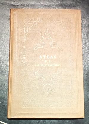
ATLAS. [rule] NARRATIVE | OF THE | UNITED STATES | EXPLORING EXPEDITION. | DURING THE YEARS | 1838, 1839, 1840, 1841, 1842. | BY |CHARLES WILKES, U. S. N. | COMMANDER OF THE EXPEDITION, |MEMBER OF THE AMERICAN PHILOSOPHICAL SOCIETY, ETC. | IN FIVE VOLUMES, AND AN ATLAS. [RULE] PHILADELPHIA: | LEA & BLANCHARD. | 1845. [[ATLAS ONLY]]
Publicado por LEA & BLANCHARD, PHILADELPHIA, 1845
Librería: T. W. Palmer Books, Eugene, OR, Estados Unidos de America
Valoración del vendedor:

Libro
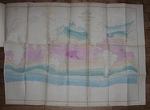
Hardcover. Condición: Very Good. No Jacket. 26.5 X 17 cm, four blank and three printed pages with blank verso, ENTERED ACCORDING TO THE ACT OF CONGRESS, IN THE YEAR 1844, BY CHARLES WILKES, U. S. N. | IN THE CLERK'S OFFICE OF THE DISTRICT COURT FOR THE DISTRICT OF COLUMBIA. [rule] STEREOTYPED BY J. FAGAN. |PRINTED BY C. SHEMAN. [rule]; CONTENTS. [rule] TRACK MAP. | (COLORED.) | This Map shows the tracks of the vessels of the Exploring Squadron, combined, and acing separately; the direction of the winds;the currents, their direction and velocity;the isothermal lines for every five degrees of temperature, from the point of perpetualcongelation to the Torrid Zone. (See explanation on Map.) | MAP OF THE ARCTIC CONTINENT. | It exhibits the daily tracks of the vessels along the land discovered by the Expedition,--the winds, currents, temperature, lines of variation, and icy barrierby which it is bounded. MAP OF THE FEEJEE GROUP. | this Map embracesthe Viti or Fejee Group, consusting of one hundred and fifty-four islands, with numerous coral reefs, &c MAP OF THE OREGON GROUP. | Thos embraces the United States possessions west of the Rocky Mountains, betweenparallels 42 and 54 40' N., and also shows Fremont's Pass through the Rocky Mountains. MAP OF THE SOUTHEAST PORTION OF HAWAII. | This Map exhibits the two remakablevolcanic mountains viited by the Expedition, with their numerouscraters, together with the great eruption of 1840, and the track of the party to and from the crater of Moku-a Loa. Original binding; marbeled boards (worn) and original leather binding with six gilt bands, marbeled front and read end papers PROVENANCE: Book Plate of Mirajah H. Clark "Vola Vita mea" (My life is devoted.) \| FIVE LARGE FOLDING MAPS.
-
Narrative of the United States Exploring Expedition. During the years 1838, 1839, 1840, 1841, 1842.
Publicado por Philadelphia: Lea and Blanchard, 1845., 1845
Librería: Arader Galleries - AraderNYC, New York, NY, Estados Unidos de America
Valoración del vendedor:
WILKES, Charles (1798-1877). Narrative of the United States Exploring Expedition. During the years 1838, 1839, 1840, 1841, 1842. Philadelphia: Lea and Blanchard, 1845. 6 volumes. 5 text volumes. Imperial 8vo., (11 x 7 inches). Half-titles. Engraved frontispiece portrait of Wilkes, 9 folding maps, 63 engraved plates, and numerous engravings and vignettes throughout. Atlas volume: (11 x 7 inches). Five large folding lithographic maps, the "Chart of the World." with contemporary hand-color (one or two short marginal tears). Original brown publisher's cloth, gilt (some extremities scuffed with minor loss). Provenance: Bookplate of Irving W. Robbins Jr tipped in between the front endpapers of each volume. "THE UNITED STATES EQUIVALENT TO THE VOYAGES OF JAMES COOK, JEAN FRANCOIS GALAUP DE LAPEROUSE, ALEJANDRO MALASPINA, AND IVAN FEDOROVICH KRUZENSHTERN FOR ENGLAND, FRANCE, SPAIN, AND RUSSIA, AND THE MARITIME EQUIVALENT OF LEWIS AND CLARK" (W. Michael Mathes). The third issue overall, and preceded by a very rare quarto edition of about 100 copies (of which 25 were destroyed by fire) published in 1844, and a limited issue of 150 copies for private distribution. This issue is limited to 1000 copies, see Haskell 16B. The large maps in the atlas are: "Chart of the World Shewing the Tracks of the U.S. Exploring Expedition in 1838, 39, 40, 41 & 42. Charles Wilkes Esq. Commander", engraved by Sherman & Smith N.Y. A fine map following Mercator's projection, showing winds and currents, the tracks of the ships Vincennes, Peacock, Porpoise, Flying Fish, Oregon, and Relief. "Chart of the Antarctic Continent Shewing the Icy Barrier Attached to it. Discovered by the U.S. Ex. Ex. Charles Wilkes. Esq, Commander 1840" Engraved by Sherman & Smith, N.Y. A fine map with Victoria (Australia) and Van Dieman's Land shaded in, showing the tracks of the ships Vincennes, Peacock, Porpoise, and Flying Fish along the coast of Antarctica, with five profile views of the Antarctic continent. "Chart of the Viti Group or Feejee Islands by the U.S. Ex. Ex. Charles Wilkes Esq. Commander 1840", engraved by Sherman & Smith, N.Y. A very detailed chart of the islands. "Map of the Oregon Territory by the U.S. Ex. Ex. Charles Wilkes Esqr. Commander. 1841", engraved by J. H. Young & Sherman & Smith, N.Y. A magnificent map (reduced in size for the later editions) with an inset of the "Columbia River Reduced from a Survey Made by the U.S. Ex. Ex. 1841" showing the area of Oregon Territory as claimed by the United States, extending well north of Vancouver, west from the Black Hills, north to just above the fifty-third parallel, and south to Cape Mendocino. This is the "first official [U.S.] chart of any portion of the West Coast and covers the coast from Cape Mendocino to Queen Charlotte Islands. The inset of the Columbia River includes geography extending as far as Walla Walla. It is a handsome map printed on imported paper from copperplates purchased in France from the Depot de la Marine. The engravers themselves were European craftsmen who not only executed the work, but also trained the American apprentices, including the artist James McNeill Whistler, who served as an engraver on the Coast Survey and learned his craft from those who engraved the Wilkes charts" (Cohen, Mapping the West, pp. 120-122). "Map of Part of the Island of Hawaii Sandwich Islands Shewing the Craters and Eruption of May and June 1840. By the U.S. Ex. Ex. 1841", engraved by Sherman & Smith, Sc. N.Y. Showing the area from Hilo to the top of Mauna Loa. Wilke's celebrated circumnavigation explored extensively the coast of South America, the South Seas, Antarctica, California and the Northwest. Departing in August 1838, Wilkes rounded Cape Horn; crossed the Pacific surveying, charting, and exploring the Tuamotus, Tahiti, and Samoa; and reached Sydney, Australia, in November 1839. His ships probed Antarctic waters, cruising 1,500 miles along an unbroken ice shelf; then sailed via New Zealand and Tonga, reac.
-
Narrative of the United States Exploring Expedition. During the years 1838, 1839, 1840, 1841, 1842.
Publicado por Philadelphia: Lea and Blanchard, 1845., 1845
Librería: Arader Galleries - AraderNYC, New York, NY, Estados Unidos de America
Valoración del vendedor:
5 volumes. 8vo., (9 2/8 x 5 6/8 inches). Half-titles. Engraved frontispiece portrait of Wilkes, 9 folding maps, 63 engraved plates, and numerous engravings and vignettes throughout (some minor spotting). Contemporary tan calf gilt (extremities scuffed with some loss, hinges weak). Provenance: Contemporary ownership inscription of "Burt" on the front free endpaper of each volume; later ownership inscription of D.M. Wilson on front free endpaper of each volume. Second trade edition, published without an Atlas. Wilke's celebrated circumnavigation explored extensively the coast of South America, the South Seas, Antarctica, California and the Northwest. Departing in August 1838, Wilkes rounded Cape Horn; crossed the Pacific surveying, charting, and exploring the Tuamotus, Tahiti, and Samoa; and reached Sydney, Australia, in November 1839. His ships probed Antarctic waters, cruising 1,500 miles along an unbroken ice shelf; then sailed via New Zealand and Tonga, reaching Fiji in May 1840. In September 1840 Wilkes reached Hawaii, and arrived off the Oregon coast in April 1841, "Wilkes found the mouth of the Columbia a difficult and dangerous harbor. He recommended emphatically in his reports that Puget Sound and the Straits of Juan de Fuca be retained in the ongoing border negotiations between the United States and Britain. In California, describing the potential for a large commercial harbor in San Francisco Bay, he emphasized the lack of Mexican government control of the area. The expedition left San Francisco on 1 November 1841, crossing the Pacific again via Hawaii, Manila, and Singapore to Cape Town. Charting, surveying, and scientific studies were conducted along the route. The voyage ended in New York in June 1842" (Roberta A. Sprague for ANB). Sabin 103994; Howes W-414.

![Imagen del vendedor de Narrative of the United States Exploring Expedition. During the Years 1868, 1839, 1840, 1841, 1842. Five [5] Volumes a la venta por Resource Books, LLC](https://pictures.abebooks.com/inventory/md/md30951625609.jpg)