
Importe total (1 artículo artículos):
Destino del pedido:

national geographic society william peele (4 resultados)
Tipo de artículo
- Todos los tipos de productos
- Libros (4)
- Revistas y publicaciones
- Cómics
- Partituras
- Arte, grabados y pósters
- Fotografías
- Mapas
- Manuscritos y coleccionismo de papel
Condición
Encuadernación
Más atributos
Gastos de envío gratis
- Gastos de Envío Gratis a EEUU
Ubicación del vendedor
Valoración de los vendedores
-
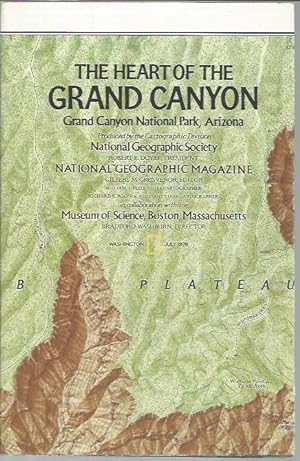
The Heart of The Grand Canyon (Map, July 1978)
Publicado por National Geographic Society, Washington, D.C., 1978
Librería: Bookfeathers, LLC, Lewisburg, PA, Estados Unidos de America
Valoración del vendedor:

Libro
Paperback. Condición: NF. Color (brown and green) map with relief shading; enhanced satellite image, sectional drawing and text on opposite side, originally accompanied magazine issue of July 1978. 16 panels, folds to roughly 5 5/8"x 9 3/4". NF. Mild toning to white borders and backgond with colors clean and strong. Mild occasional wear along edges.
-

The Red Planet Mars; The Dusty Face of Mars
Publicado por National Geographic Society, Washington DC, 1973
Librería: Ground Zero Books, Ltd., Silver Spring, MD, Estados Unidos de America
Valoración del vendedor:
Original o primera edición
Map/Poster. Condición: Good. William T. Peele (Chief Cartographer), and Jay L. Ilustrador. Format is approximately 22 inches by 38 inches. Index. Glossary. Small tear a center fold between bottom and next lower panel fold. Item has some wear. Folded to fit inside the magazine as a supplement (16 panels approximately 5.5 inches by 9.5 inches). Illustration and text on both sides. This poster/map was a supplement to the National Geographic, February 1973, Volume 143, No. 2 Mars. The front side has three large Equatorial Views (Central Meridian 120 degrees, Central Meridian 0 degrees, and Central Meridian 240 degrees) and to smaller circular images (North Polar Area and South Polar Area). There are text sections on Seasons on Mars, Retrograde Motion, Conjunction, Opposition, Surface Color, Polar Caps, Atmosphere, Clouds, Winds, Temperature, Weight, and Magnetic Fields. The back side is titled The Dusty Face of Mars and is mostly a large pictorial. There is some text and an index and glossary. One text section is entitled Satellites of Mars. National Geographic Maps, founded in 1915, is a wholly owned division of the National Geographic Society. The Maps division is responsible for the creation of Society cartographic products including page maps in National Geographic Magazine, travel maps, wall maps, atlases, TOPO! mapping software, Trails Illustrated hiking maps, and globes. National Geographic Maps is responsible for illustrating the world around us through the art and science of mapmaking. National Geographic Maps continues this mission by creating the world's best wall maps, outdoor recreation maps, travel maps, atlases and globes that inspire people to care about and explore their world. Presumed First Edition, First printing thus.
-

National Geographic atlas of the world / Melville Bell Grosvenor, editor-in-chief, Gilbert M. Grosvenor, editor ; William T. Peele, chief cartographer ; David W. Cook, associate chief cartographer ; Jules B. Billard, atlas text
Publicado por National Geographic Society, 1975
ISBN 10: 087044137XISBN 13: 9780870441370
Librería: MW Books, New York, NY, Estados Unidos de America
Valoración del vendedor:
Libro
Fourth Edition. Fine cloth copy in a near fine, very slightly edge-nicked and dust-dulled dust wrapper, now mylar-sleeved. Remains particularly and surprisingly well-preserved; tight, bright, clean and sharp-cornered. Physical description; 330 p. : col. ill., col. maps ; 48 cm. Notes; Maps produced by the Cartographic Division, National Geographic Society. Subjects; Atlases. Geography. Genres; Illustrated. 3 Kg.
-
National Geographic atlas of the world / Melville Bell Grosvenor, editor-in-chief, Gilbert M. Grosvenor, editor ; William T. Peele, chief cartographer ; David W. Cook, associate chief cartographer ; Jules B. Billard, atlas text
Publicado por National Geographic Society, 1975
ISBN 10: 087044137XISBN 13: 9780870441370
Libro
Fourth Edition. Fine cloth copy in a near fine, very slightly edge-nicked and dust-dulled dust wrapper, now mylar-sleeved. Remains particularly and surprisingly well-preserved; tight, bright, clean and sharp-cornered. Physical description; 330 p. : col. ill., col. maps ; 48 cm. Notes; Maps produced by the Cartographic Division, National Geographic Society. Subjects; Atlases. Geography. Genres; Illustrated. 3 Kg.
