
Importe total (1 artículo artículos):
Destino del pedido:

l p g dow (8 resultados)
Ir a los resultados principales
Tipo de artículo
- Todo tipo de artículos
- Libros (6)
- Revistas y publicaciones
- Cómics
- Partituras
- Arte, grabados y pósters
- Fotografías
- Mapas (2)
-
Manuscritos y
coleccionismo de papel
Condición
Encuadernación
- Todo
- Tapa dura
- Tapa blanda
Más atributos
- Primera edición (1)
- Firmado
- Sobrecubierta
- Con imágenes del vendedor (2)
- Sin impresión bajo demanda (7)
Ubicación del vendedor
Valoración de los vendedores
-

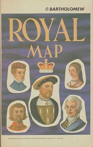
Royal Map
Publicado por John Batholomew & Son, LTD.
Librería: Hastings of Coral Springs, Altamonte Springs, FL, Estados Unidos de America
Valoración del vendedor:

Mapa
Soft cover. Condición: Good. No Jacket. Joan Robinson Ilustrador. 5th or later Edition. A large single sheet in paper covers. The covers are foxed and rubbed. A sticker is attached to the front cover.
-
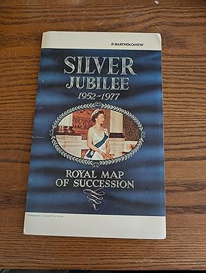
Silver Jubilee 1952-1977 Royal Map of Succession
Publicado por Bartholomew & Sin Ltd, Edinburgh, 1977
Librería: Adamstown Books, Lancaster, PA, Estados Unidos de America
Valoración del vendedor:
Libro
Soft cover. Condición: Very Good. No Jacket. Robinson, Joan Ilustrador. The sovereign line of Great Britain in a pictorial fold-out poster-sized map 32" by 40". "At the top left-hand corner is a selection of ancestors from the Anglo-Saxon, Welsh and Danish background, and arrows lead the eye through the last 9 centuries of the royal line" - from the text. Color-illustrated softcover, folded map glued in. Condition: Very good; slight creases along the spine, mild toning at some folded edges.
-
SOUVENIR ROYAL MAP The Marriage of the Prince of Wales and Lady Diana Spencer
Publicado por Bartholomew, 1981
Librería: The Avocado Pit, Staunton, VA, Estados Unidos de America
Miembro de asociación: IOBA
Valoración del vendedor:
Paperback. Condición: Very Good. Illustrated by Joan Robinson Ilustrador. Small 4to 9" - 11" tall.
-
COUV. SOUPLE. Condición: TRES BON. ROBINSON JOEN Ilustrador. EN BON ETAT ILLUSTREE - PORT POUR LA Belgique 4 - France 8,20 16X26 100g.
-
How to Assess Maturation and Paleotemperatures (Society of Economic Paleontologists and Mineralogists Short Course Number Seven / 7).
Publicado por Society of Economic Paleontologists and Mineralogists., 1982
Librería: Eryops Books, Stephenville, TX, Estados Unidos de America
Valoración del vendedor:
Soft cover. Condición: Very Good. Softcovers; ex-corporate library; in very good condition. Book.
-
ROYAL MAP OF SUCCESSION SILVER JUBILEE 1952-1977
Publicado por Bartholomew, Edinburgh, 1977
ISBN 10: 0851526993ISBN 13: 9780851526997
Librería: Paraphernalia Books 'N' Stuff, Belleville, ON, Canada
Valoración del vendedor:
Libro
Soft cover. Condición: Very Good. No Jacket. Joan Robinson Ilustrador. First. Pictorial map produced to commemorate the Queen's Silver Jubilee in 1977; Map has no tears but a little agetoned with slight smoke odour; Shows the line of Succession for both English & Scottish Crowns; Fully illut.in colour with map of British Isles highlighting famous places & areas connected to the Crown;
-
Silver Jubilee 1952-1977 - Royal Map of Succession
Publicado por Bartholomew, 1977
Librería: The Mill Bookshop, Gatehouse of Fleet, Reino Unido
Valoración del vendedor:

Mapa Original o primera edición
Soft cover. Condición: Very Good. 1st Edition. Edinburgh: Bartholomew & Son Ltd, 1977. Illustrated by Joan Robinson, text by L.P.G. Dow. Soft cover. 4to - over 9ľ - 12" tall. The sovereign line of Great Britain in a pictorial fold-out poster-sized map 32" by 40". "At the top left-hand corner is a selection of ancestors from the Anglo-Saxon, Welsh and Danish background, and arrows lead the eye through the last 9 centuries of the royal line" - from the text. Colour-illustrated softcover, folded map glued in. Condition: Very good, some rubbing on front cover.
-

Sermons and Addresses on Secret Societies
Publicado por BiblioBazaar, 2009
ISBN 10: 1117150259ISBN 13: 9781117150253
Libro Impresión bajo demanda
Paperback. Condición: Brand New. 314 pages. 8.75x5.75x0.70 inches. This item is printed on demand.
