Importe total (1 artículo artículos):
Destino del pedido:

blaeu joannes (37 resultados)
Ir a los resultados principales
Tipo de artículo
- Todo tipo de artículos
- Libros (33)
- Revistas y publicaciones
- Cómics
- Partituras
- Arte, grabados y pósters (1)
- Fotografías
- Mapas (3)
-
Manuscritos y
coleccionismo de papel
Condición
- Todo
- Nuevos
- Antiguos o usados
Encuadernación
- Todo
- Tapa dura (4)
- Tapa blanda
Más atributos
- Primera edición (2)
- Firmado
- Sobrecubierta
- Con imágenes del vendedor (22)
- Sin impresión bajo demanda
Ubicación del vendedor
Valoración de los vendedores
-
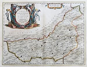
Dioecesis Sarlatensis, Vernacule Le Dioecese de Sarlat" - Sarlat-la-Caneda Bergerac Dordogne Eymet Lalinde Monbazillac Monpazier Domme Montignac Terrasson-Lavilledieu Nouvelle-Aquitaine France Frankreich carte
Publicado por Amsterdam ca. 1640., 1640
Librería: Antiquariat Steffen Völkel GmbH, Seubersdorf, Alemania
Miembro de asociación: ILAB VDA
Valoración del vendedor:

Mapa
Große altkolorierte Kupferstich-Karte von ca. 1640. -- Mit lateinischem Text auf der Rückseite. -- Blatt-Maße: ca. 50 x 59 cm. -- gut erhalten. || Large old colored map from ca. 1640. With Latin text on verso. -- in good condition. || Dies ist ein Original! - Kein Nachdruck! - Keine Kopie! -- This is an original! - No copy! - No reprint! la.
-
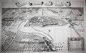
Carmagnoliae Eiusq. Vicorum Nova et Exactissima Descriptio" - Carmagnola Piemonte veduta Italia Italy Italien incisione
Publicado por Den Haag, Alberts, 1726
Librería: Antiquariat Steffen Völkel GmbH, Seubersdorf, Alemania
Miembro de asociación: ILAB VDA
Valoración del vendedor:
Arte / Grabado / Póster
Seltener prächtiger Kupferstich aus Blaeu's Städtebuch von Piemont-Savoyen: "Novum Theatrum Pedemonti et Sabaudiae". Aus der Ausgabe von 1726. -- Von 2 Platten gedruckt. -- Blatt-Maße: ca. 85 x 57,5 cm; Platte ca. 83 x 51 cm. -- gut erhalten. || Beautiful rare engraving out of the 1726 edition of Blaeu's work: "Novum Theatrum Pedemonti et Sabaudiae". -- Printed on two plates, joined. -- in good condition. || Bella rara incisione tratta dall'edizione del 1726 del libro di Blaeu: "Novum Theatrum Pedemonti et Sabaudiae". -- in buone condizioni. la Gewicht in Gramm: 1550.
-
Fanvm S. Avdomari Vulgo S. Omer
Publicado por Blaeu, Joan, Amsterdam, 1649
Librería: Antikvariat Krenek, Prag, Republica Checa
Miembro de asociación: ILAB
Valoración del vendedor:
"Fanum S. Audomari Vulgo S. Omer". Orig. copperplate engraving from J. Blaeu's Städtebuch, 1649. With ornamental title-cartouche and 2 great coats-of-arms (one blank). 38,5:49,5 cm (15 1/4 x 19 1/2 inch.). A birds-eye-view and fortification plan of the city of St-Omer in northern France.
-
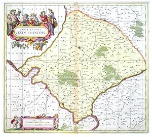
Carte dv Pays Vexin Francois
Publicado por Valck, Gerard - Schenk, Peter, Amsterdam, 1690
Librería: Antikvariat Krenek, Prag, Republica Checa
Miembro de asociación: ILAB
Valoración del vendedor:
"Carte du Pays Vexin Francois". Orig. copperplate engraving. Published by P. Schenk and G. Valk in Amsterdam, ca. 1690. Orig. old colouring. With great figure title-cartouche and ornamnetal chartouche with the scale of map ("Milliaria Gallica") and 3 cherubs. 44:49,5 cm (17 1/2 x 19 1/2 inch.). A very decorative map of the region north of Paris. Centered on the city of Chaumont-en-Vexin. With the cities of Vernon, Mantes-la-Jolie, Meulan, Poissy, Pontoise, Beaumont-sur-Oise and Beauvais. - Price includes the passe-partout (61:66 cm; 24 x 26 inch.).
-
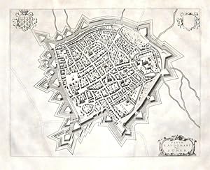
Insvla, Vulgo Lille, Belgice Riisel
Publicado por Blaeu, Joan, Amsterdam, 1649
Librería: Antikvariat Krenek, Prag, Republica Checa
Miembro de asociación: ILAB
Valoración del vendedor:
"Insula, Vulgo Lille, Belgice Riisel". Orig. copperplate engraving from J. Blaeu's Städtebuch, 1649. With ornamental title-cartouche with explanatory notes (1.-6.) and 2 great coats-of-arms. 38:49 cm (15 x 19 1/4 inch.). A birds-eye-view and fortification plan of the city of Lille in northern France.
-
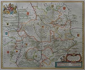
Episcopatus Hildesiensis Descriptio Novissima
Ańo de publicación: 1640
Librería: Kunstantiquariat Andreas Senger, Hamburg, Alemania
Valoración del vendedor:
Mapa
Kein Einband. Condición: Gut bis sehr gut. Es handelt sich hierbei um eine originale, kolorierte Kupferstich-Landkarte des Gebietes des Bistums Hildesheim von Joannes Gigas bei Willem Janszoon Blaeu (1571 - 1638), ca. aus dem Jahr 1640. *** Titel: Episcopatus Hildesiensis Descriptio Novissima *** Gebiet bzw. Ort: Bistum Hildesheim *** Kartograph: Joannes Gigas bei Willem Janszoon Blaeu (1571 - 1638) *** Jahr: 1640 *** Größe des Plattenbereichs: 41 x 50 cm *** Technik: Kupferstich *** Zustand (Perfekt/ Sehr gut/ Gut/ Ordentlich/ Mäßig/ Schlecht): In sehr gutem Erhaltungszustand *** Bemerkungen: Leichte Knickspur oben links. - - - International buyers welcome. If you have any questions, please don't hesitate to ask. --- Auf Wunsch stellen wir Ihnen gerne ein kostenfreies Echtheitszertifikat aus --- If you wish, we will gladly provide a certificate of authenticity free of charge ---.
-
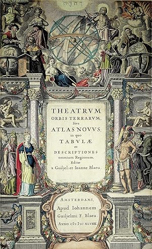
THEATRUM ORBIS TERRARUM, Sive ATLAS NOVUS; in quo TABULAE et Descriptiones omnium Regionum, Editae a Guiljel: et Joanne Blaeu
Publicado por Blaeu 1649(orig 1635, Amsterdam, 1649
Librería: Quiet Friends IOBA, Lyndonville, NY, Estados Unidos de America
Miembro de asociación: IOBA
Valoración del vendedor:
RECENT, flawless, recoloring Ilustrador. FINE main title page of the multi volumn atlas. Size inside mat 39cm X 23.5cm. Bright & very attractive hand coloring. This atlas first published in 2 vols in 1635. By 1655 it had expanded to 6. Matted & framed, under glass, likely with later hand coloring. Coloring superb. It is so good it likely had been professionally cleaned and recolored. FINE title page of the whole atlas, not just one of the parts.
-
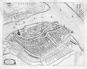
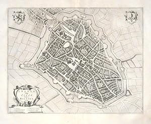
Dordrecht
Publicado por Blaeu, Johann, Amsterdam, 1649
Librería: Antikvariat Krenek, Prag, Republica Checa
Miembro de asociación: ILAB
Valoración del vendedor:
Dordrecht. "Dordrecht". Orig. copperplate engraving, J. Blaeu, 1652. With ornemental title cartouche, 2 coats-of-arms and explanatory notes (1-31). 42:53 cm (16 1/2 x 20 3/4 inch). Koeman IV, map 1116, ed. 43:113 (Lat.). - A birds eye view of the city of Dordrecht from Blaeu's Theatrum urbim Belgicae.
-
Ducatus Chablasius et Lacus Lemanus, cum Regionibus adjacentibus
Publicado por Lago di Ginevra
Librería: Sergio Trippini, Gavirate, Italia
Miembro de asociación: ALAI ILAB
Valoración del vendedor:
Carta geografica del lago e delle regioni adiacenti. Titolo entro drappo sostenuto da putti. Piega centrale.
-
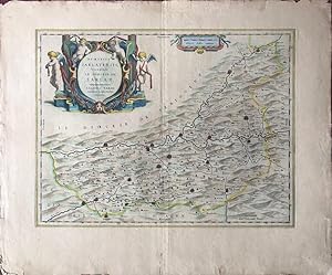
Dioecesis Sarlatensis, Vernacule Le Dioecese de Sarlat. Ioannes Tardo Canonicus Ecclesiae Sarlati delineabat.
Publicado por Amsterdam: Blaeu, [c.1635]., 1635
Librería: William Matthews/The Haunted Bookshop, Sidney, BC, Canada
Miembro de asociación: ABAC ILAB
Valoración del vendedor:

Copper engraved map on laid paper, large coloured cartouche in upper left, and a smaller one on upper margin. Hand-colouring to entire map. Plate size is 50cm x 38cm, on a sheet measuring 64cm x 54cm. Text on verso is in Dutch, headings are SARLAT and Het Bisdom SARLAT IN PERIGORT. Tailpiece and initial on verso. Page number on verso is 40, signature mark Qq. Imprint at lower right: Amsterdami Apud Guiljelmum Blaeu. Short tears to margins, small yellowed tape repair on verso by fold, a clean very good copy. Probably from the Dutch edition of the atlas: Theatrum Orbis Terrarum sive Atlas Novus / Volume II, published by Willem and Joan Blaeu, [1635-1655]. [Dutch title: Toonneel // des Aerdrycks, // ofte // Nievwe Atlas, // Dat is // Beschryving // van alle Landen; // Nu nieulycx uytgegeven, // Door // Wilhelm: en Iohannem Blaeu. Amsterdami; // Apud Guiljelmum // et 1ohannem Blaeu. // Anno MDCXXXV]. A map of the Sarlat region of France by Joannes Tardo, including Bergerac, Couse, Lalinde, Limcul, Montignac Terrasson, Sarlat, Domme, S. Cyprien, Beleur, Ville Franche, Mont Pazier, Villercal, Cshillons, Lauzum, Ayment, Lasluetat, Beaumont, Molieres, Sisgeac and Beluer. A large and handsome cartouche, attractively coloured.
-
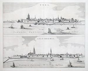
Tyel - Salt-Boemel
Publicado por Blaeu, Johann, Amsterdam, 1649
Librería: Antikvariat Krenek, Prag, Republica Checa
Miembro de asociación: ILAB
Valoración del vendedor:
"Tyel. Salt-Boemel". Kupf. (aus dem Städtebuch von J. Blaeu, 1649). 2 Gesamtansichten von Tiel (oben) u. ZaltBommel (unten) auf 1 Blatt. Mit Shiffsstaffage. 42,5:43,5 cm.
-
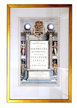
Title-Page: Achtste Stuck der Aerdrycks-Beschryving welck vervat Spaenjen, Africa, en America
Publicado por In de Druckery van Joan Blaeu, Amsterdam, 1665
Librería: James Cummins Bookseller, ABAA, New York, NY, Estados Unidos de America
Miembro de asociación: ABAA ILAB
Valoración del vendedor:
Image 10 x 16 inches. Condición: Framed and glazed. Image 10 x 16 inches.
-
March. Brandenburgici Pars, quae Marchia Media vulgo Mittelmarck audit (Altkolorierter Kupferstich aus Atlas Major bei J. Blaeu, Amsterdam)
Publicado por Blaeu, Amsterdam, 1662
Libro
40x52cm Karte gerahmt, leicht sichtbare Mittelfalte, sonst gutes Ex. Sprache: Latein, Mit figürlicher Titelkartusche mit Wildschwein, Hund und Hirsch sowie Meilenzeiger mit Putte und Geometer, ferner ein nicht ausgefülltes Wappenschild in der oberen rechten Ecke. Dekorative, breitrandige Karte der Mittelmark mit Berlin im Zentrum.
-

Guiana sive Amazonum Regio
Publicado por Amsterdam: Blaeu, 1655., 1655
Librería: Arader Galleries - AraderNYC, New York, NY, Estados Unidos de America
Valoración del vendedor:
Single sheet (20 x 23 4/8 inches; 14 4/8 x 19 inches). Fine engraved map of Guyana, the title, scale and imprint within fine mannerist and allegorical cartouches, the ocean decorated with a large compass rose and three galleons, all with original hand-colour in outline. A fine and attractive map of Guyana, showing Lake Parime, a very small El Dorado, and a long Amazon River. Although Columbus sighted Guayan on his third voyage it was settled by the Dutch rather than the Spanish. Tales of the mythical city of gold, El Dorado, led Sir Walter Raleigh to modern Venezuela. Although the city was not found, Raleigh argued that Guiana had the potential to yield many riches, and be an advantageous English stronghold against the Spanish: "Guiana is a Country that hath yet her Maydenhead, never sackt, turned, nor wrought, the face of the earth hath not beene torne, not the virtue and salt of the soyule spent by manurance, the graves have not beene opened for gold, the mines not broken with sledges, nor their Images puld down out of their temples. It hath never been entered by any armie of strength, and never conquered or possessed by any Chrisitian Prince. It is besides so defensible, that if two fortes be builded in one of the provinces which I have seen, the flood setteth in so neere the banke, where the channel also lyeth, that no shippe can passé up, but with Pikes length of the Artillerie, first of the one, and afterwards of the other." (Raleigh pages 96-97). Shakespeare is believed to have obtained his knowledge of the "still vexed Bermoothes" for "The Tempest" from Raleigh's account of Guyana. Publication of Blaeu's New World Atlas, or "Atlas Novus" was originally begun by Joannes's father Willem Blaeu with the publication in 1635 of two volumes (consisting of The World, Europe, Arctic, Scandinavia, Russia, Eastern Europe, Germany and the Low Countries; and France, Spain, Asia, Africa and America), and published in four languages (German, Dutch, Latin and French). After succeeding his father, Joannes Blaeu progressively expanded the "Atlas Novus" to six volumes by 1655, and this formed the first half the "Atlas Maior," extending to 11 or 12 volumes by 1662.
-
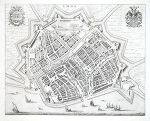
Emda
Publicado por Blaeu, Johann, 1649
Librería: Antikvariat Krenek, Prag, Republica Checa
Miembro de asociación: ILAB
Valoración del vendedor:
"Emda". Vogelschauansicht. Kupf. (von J. Blaeu aus dem Städtebuch, 1649). Mit 2 Wappen. 42,5:53 cm. Zeigt Emden.
-
Terra Firma et Novum Regum Grantense et Popayan
Publicado por Amsterdam: Blaeu, 1655., 1655
Librería: Arader Galleries - AraderNYC, New York, NY, Estados Unidos de America
Valoración del vendedor:
Single sheet (20 x 23 4/8 inches; 15 x 19 inches to the neat line). Fine engraved map of north-west South America, the title and scale within a fine mannerist cartouches, the ocean decorated with two compass roses, all with original hand-colour in outline and in part. A fine and attractive map of modern Panama and Columbia. During the Spanish colonial era the Isthmus of Panama was known as Tierra Firma (firm ground), a small stretch of land dividing the Atlantic and Pacific Oceans. The first European to explore the Isthmus was the Spanish explorer Rodrigo de Galván Bastidas in 1501. The following year Christopher Columbus also landed on the northern coast. Publication of Blaeu's New World Atlas, or "Atlas Novus" was originally begun by Joannes's father Willem Blaeu with the publication in 1635 of two volumes (consisting of The World, Europe, Arctic, Scandinavia, Russia, Eastern Europe, Germany and the Low Countries; and France, Spain, Asia, Africa and America), and published in four languages (German, Dutch, Latin and French). After succeeding his father, Joannes Blaeu progressively expanded the "Atlas Novus" to six volumes by 1655, and this formed the first half the "Atlas Maior," extending to 11 or 12 volumes by 1662.
-
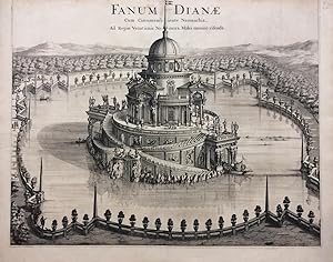
Fanum Dianae; Cum Circumambiente Naumachia, Ad Regiae Venationis Nemora, Moles omnino visenda
Publicado por Joannes Blaeu, Amsterdam, 1680
Librería: Argosy Book Store, ABAA, ILAB, New York, NY, Estados Unidos de America
Miembro de asociación: ABAA ILAB
Valoración del vendedor:
unbound. Print. Uncolored engraving. Image measures 19.25 x 24 inches, sheet measure 20.5 x 26 inches. Shows some light foxing, as well as a repaired ~2 inch tear at left margin. Top edge trimmed to neat line. In very good condition. Outstanding view of a baroque pleasure palaces and garden from 'Theatrum Statuum Regiae Sabaudiae'. The series features maps, topographic views of Turin and cities and towns of Piedmont and Savoy. One of the most prolific Dutch mapmakers of his time, Willem Blaeu (1571-1638) started one of the most famous map publishing firms of the 17th century. It was at this time that the Dutch controlled the map trade, and their ornate and beautiful maps had immense popularity. Blaeu and his family worked out of Amsterdam and was instrumental in driving this dominance in his lifetime, and this legacy was continued by his sons. "Theatrum Statuum Regiae Sabaudiae" was published by his son Johannes (c. 1599-1673), who took over the business upon his father's death.
-
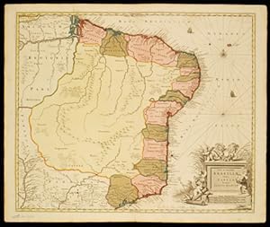
Brasilia
Publicado por Amsterdam: Blaeu, 1655., 1655
Librería: Arader Galleries - AraderNYC, New York, NY, Estados Unidos de America
Valoración del vendedor:
Single sheet (20 x 23 4/8 inches; 15 x 19 inches). Fine engraved map of Brasil, oriented to the west, the title, scale within fine elaborate mannerist and allegorical cartouches, the ocean decorated with two compass roses and three galleons, all with original hand-colour in outline. A fine and attractive map of Brasil, first discovered by Pedro Álvares Cabral in 1500, while en route to India via the Cape of Good Hope, who claimed it for Portugal. The map includes the region from the mouth of the Amazon river to the La Plata. Publication of Blaeu's New World Atlas, or "Atlas Novus" was originally begun by Joannes's father Willem Blaeu with the publication in 1635 of two volumes (consisting of The World, Europe, Arctic, Scandinavia, Russia, Eastern Europe, Germany and the Low Countries; and France, Spain, Asia, Africa and America), and published in four languages (German, Dutch, Latin and French). After succeeding his father, Joannes Blaeu progressively expanded the "Atlas Novus" to six volumes by 1655, and this formed the first half the "Atlas Maior," extending to 11 or 12 volumes by 1662.
-
Chili
Publicado por Amsterdam: Blaeu, 1655., 1655
Librería: Arader Galleries - AraderNYC, New York, NY, Estados Unidos de America
Valoración del vendedor:
Single sheet (20 x 23 4/8 inches; 14 x 19 inches to the neat line). Fine engraved map of Chile, the title, imprint, and scale with elaborate rococo cartouches, the key within a scroll, and decorated with two compass roses, ships and sea monsters, Latin text on verso (a little toned, one or two marginal spots). A beautiful map of Chili from Blaeu's "Theatrum orbis terrarum, sive atlas novus. Pars secunda". Publication of Blaeu's New World Atlas, or "Atlas Novus" was originally begun by Joannes's father Willem Blaeu with the publication in 1635 of two volumes (consisting of The World, Europe, Arctic, Scandinavia, Russia, Eastern Europe, Germany and the Low Countries; and France, Spain, Asia, Africa and America), and published in four languages (German, Dutch, Latin and French). After succeeding his father, Joannes Blaeu progressively expanded the "Atlas Novus" to six volumes by 1655, and this formed the first half the "Atlas Maior," extending to 11 or 12 volumes by 1662.
-
Venezuela.
Publicado por Amsterdam: Blaeu, 1655., 1655
Librería: Arader Galleries - AraderNYC, New York, NY, Estados Unidos de America
Valoración del vendedor:
Single sheet (20 x 23 4/8 inches; 14 4/8 x 19 inches). Fine engraved map of Venezuela the title and scale with fine mannerist and allegorical cartouches, the ocean decorated with two compass roses and a galleon, the land with birds and animals, all with original hand-colour in outline. It was on his third voyage in 1498 that Columbus discovered mainland America, exploring the coastline of what is now known as Venezuela: "Great signs are these of the Terrestrial Paradise, for the site conforms to the opinion of the holy and wise theologians whom I have mentioned. And likewise, the [other] signs conform very well, for I have never read or heard of such a large quantity of fresh water being inside and in such close proximity to salt water; the very mild temperateness also corroborates this; and if the water of which I speak does not proceed from Paradise then it is an even greater marvel, because I do not believe such a large and deep river has ever been known to exist in this world" (recorded by Zamora, Margarita (1993). Reading Columbus. University of California Press. pp. Voyage to Paradise, page 141). Publication of Blaeu's New World Atlas, or "Atlas Novus" was originally begun by Joannes's father Willem Blaeu with the publication in 1635 of two volumes (consisting of The World, Europe, Arctic, Scandinavia, Russia, Eastern Europe, Germany and the Low Countries; and France, Spain, Asia, Africa and America), and published in four languages (German, Dutch, Latin and French). After succeeding his father, Joannes Blaeu progressively expanded the "Atlas Novus" to six volumes by 1655, and this formed the first half the "Atlas Maior," extending to 11 or 12 volumes by 1662.
-
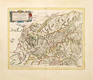
Braid-Allaban, Atholia, Marria Superior, Badenochia, Strath-Spea, Lochharbia. A description of the inland provinces of Scotland lying between the Tay River and Murray Firth.
Publicado por Amsterdam: [1654], 1654
Librería: Peter Harrington. ABA/ ILAB., London, Reino Unido
Miembro de asociación: ABA ILAB PBFA
Valoración del vendedor:
Dutch edition. A glorious, highly detailed map of north eastern Scotland by Blaeu, based on the earlier surveys of Robert Gordon. Map is orientated to the north. One of the central features of the map is the River Spey, the second longest and the fastest-flowing river in Scotland. It is important for salmon fishing and whisky production. A decorative, rococo style title cartouche dominates the upper left corner of the map. Size: 540 x 640 mm. Copperplate engraving with hand colour. Map has been cleaned and strengthened. Good condition.
-
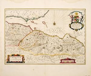
Lothian and Linlitquo.
Publicado por Amsterdam: 1664, 1664
Librería: Peter Harrington. ABA/ ILAB., London, Reino Unido
Miembro de asociación: ABA ILAB PBFA
Valoración del vendedor:
Original o primera edición
A splendidly decorative and striking map of the areas of Lothian and Linlithgow in Scotland by premier seventeenth century Dutch cartographer Joan Blaeu, from his wonderful multi-volume work entiled "Theatrum Orbis Terrarum" or "Novus Atlas". The map centres on Edinburgh, and takes in the outlying towns of Rosslyn, North Berwick, Haddington, Linlithgow and Dunbar. The map is enhanced by a number of decorative features; a compass rose in The Firth of Forth, scrolled title cartouche and mileage scale and a most attractive dedication. The Blaeu maps of Scotland are uncommon, as they were only produced between 1654, the date of their first printing, and 1672, the year of the fire that destroyed the Blaeu printing house. This is a much shorter period of time than for most of the other Blaeu maps. Size: 530 x 625 mm. Copperplate engraving with beautiful early hand colour. Dutch text on verso. Some water staining and mild damp stains to margins, small repaired tear to lower central margin, otherwise in very good condition.
-
Nova et Accurata Brasiliae totius Tabula.
Publicado por Schenk Amsterdam. c., 1720
Librería: Shapero Rare Books, London, Reino Unido
Miembro de asociación: ABA ILAB PBFA
Valoración del vendedor:
Mapa
Original hand-coloured, double-page engraved maps, blank on verso, fine impression. Slightly age toned. In 1694 Pieter Schenk acquired a number of copperplates from the Blaeu estate and published them together with maps from Janssonius and Visscher in his "Atlas Contractus". Schenk was an imminent Dutch publisher and cartographer. This is the 'New and Accurate Map of Brasil' from the atlas. This handsome map is interesting from the view point that there is next to no cartographic detail or information beyond the very edges of the coastline. Rhumb lines, a compass rose and a pair of galleons are engraved in the Atlantic ocean. The lower right corner is filled with a wonderfully elaborate title cartouche and assorted mileage scales.
-

Istria olim Iapidia.
Publicado por Amsterdam: 1648, 1648
Librería: Peter Harrington. ABA/ ILAB., London, Reino Unido
Miembro de asociación: ABA ILAB PBFA
Valoración del vendedor:
A wonderfully decorative and visually striking map by Joan Blaeu of the peninsular of Istria, situated on the Adriatic Sea, bordering Italy, Croatia and Slovenia. Blaeu's attractive map is embellished by a gorgeous title cartouche; featuring the winged Lion of Venice, together with a pair of armoured soldiers and a pair of winged mermaids either side of the pretty mileage scale in the lower right corner. All major coastal towns are highlighted in red, rivers, mountains, forests and hills are well defined, a ship is seen sailing within the Gulf of Venice. Over the centuries, Istria has been a part of the Republic of Venice; The Austrian Empire (twice); been under Napoleonic Rule and then finally a part of modern day Italy. Published in Blaeu's "Theatrum Orbis Terrarum" or "Novus Atlas". Size: 530 x 640 mm. Copperplate engraving with wonderful early hand colour. Dutch text on verso. A few minor rust marks, and some slight discolouration to the central fold, otherwise in very good condition.
-
Tabula Magellanica, qua Tierrae del fuego, cum celeberrimis fretis a F. Magellano et I. Le Maire detectis novissima et accuratissima deseriptio exhibertur.
Publicado por Amsterdam: Blaeu, 1655., 1655
Librería: Arader Galleries - AraderNYC, New York, NY, Estados Unidos de America
Valoración del vendedor:
Single sheet (20 x 23 4/8 inches; 16 x 21 inches). Fine engraved map of Tierra del Fuego. The title, key, and description of latitude and longitude within fine elaborate mannerist and allegorical cartouches, decorated with an elaborate dedication to 3 small compass roses and a fleet of seven galleons, all with original hand-colour in outline. A fine and attractive map of the southernmost tip of South America and the archipelago Tierra del Fuego, named land of fires by Ferdinand Magellan in 1520 as he circumnavigated the globe for the first time. For the next 350 years the island and the Straits of Magellan remained mostly unexplored until the British Admiralty undertook a thorough survey of the entire archipelago between 1826 and 1836. It was on the second voyage of 1836 that Charles Darwin famously joined the expedition aboard the Beagle as the official naturalist. Publication of Blaeu's New World Atlas, or "Atlas Novus" was originally begun by Joannes's father Willem Blaeu with the publication in 1635 of two volumes (consisting of The World, Europe, Arctic, Scandinavia, Russia, Eastern Europe, Germany and the Low Countries; and France, Spain, Asia, Africa and America), and published in four languages (German, Dutch, Latin and French). After succeeding his father, Joannes Blaeu progressively expanded the "Atlas Novus" to six volumes by 1655, and this formed the first half the "Atlas Maior," extending to 11 or 12 volumes by 1662.
-
Augusta Praetoria Vern. Aosta
Librería: TABERNA LIBRARIA - ALAI - ILAB, Pistoia, Italia
Miembro de asociación: ALAI ILAB
Valoración del vendedor:
Inc. in rame impreziosita da coloritura all'acquerello ottocentesca, mm. 445x1117. "Innocente Guizzaro delineavit - Joannes Blaeu excudit". In alto, al centro, stemma sabaudo; a destra, stemma del Ducato d'Aosta. Lungo il margine inferiore didascalia con 27 richiami. Grande e pittoresca veduta di Aosta e dintorni presa dalle alture di Charvensod. Molto bella, rara. Lievemente arrossata.
-
Insulae Americanae in Oceano Septentrionali cum Terris Adiacentibus
Publicado por Amsterdam: Blaeu, 1655., 1655
Librería: Arader Galleries - AraderNYC, New York, NY, Estados Unidos de America
Valoración del vendedor:
Single sheet (20 x 23 4/8 inches; 14 6/8 x 20 4/8 inches to the neat line). Fine engraved map of Central America and the West Indies, the title, dedication and scale within fine allegorical cartouches, the ocean decorated with ships, three compass roses and numerous rhumb lines, hand-coloured in part and in outline, Latin text on verso (one or two insignificant marginal spots). A beautiful map of the West Indies showing the eastern coast of North America from Chesapeake Bay to the Gulf of Mexico, Central America and the northern coast of South America. From Blaeu's "Theatrum orbis terrarum, sive atlas novus. Pars secunda". Publication of this New World Atlas, or "Atlas Novus" was originally begun by Joannes's father Willem Blaeu with the publication in 1635 of two volumes (consisting of The World, Europe, Arctic, Scandinavia, Russia, Eastern Europe, Germany and the Low Countries; and France, Spain, Asia, Africa and America), and published in four languages (German, Dutch, Latin and French). After succeeding his father, Joannes Blaeu progressively expanded the "Atlas Novus" to six volumes by 1655, and this formed the first half the "Atlas Maior," extending to 11 or 12 volumes by 1662.
-
Peru
Publicado por Amsterdam: Blaeu, 1655., 1655
Librería: Arader Galleries - AraderNYC, New York, NY, Estados Unidos de America
Valoración del vendedor:
Single sheet (20 x 23 4/8 inches; 14 4/8 x 19 inches). Fine engraved map of Peru. The title and scale within a fine elaborate mannerist strapwork cartouche, decorated with a compass rose, four galleons, and three sea monsters, all with original hand-colour in outline. A fine and attractive map of Peru, oriented to the east, showing lake Titicaca, the Andes, more than 100 places, and extending from Ecuador in the north to the Atacama desert in northern Chile. Publication of Blaeu's New World Atlas, or "Atlas Novus" was originally begun by Joannes's father Willem Blaeu with the publication in 1635 of two volumes (consisting of The World, Europe, Arctic, Scandinavia, Russia, Eastern Europe, Germany and the Low Countries; and France, Spain, Asia, Africa and America), and published in four languages (German, Dutch, Latin and French). After succeeding his father, Joannes Blaeu progressively expanded the "Atlas Novus" to six volumes by 1655, and this formed the first half the "Atlas Maior," extending to 11 or 12 volumes by 1662.
-
Mappa aestivarum insularum, alias Barmudas.
Publicado por Amsterdam: Blaeu, 1655., 1655
Librería: Arader Galleries - AraderNYC, New York, NY, Estados Unidos de America
Valoración del vendedor:
Single sheet (20 x 23 4/8 inches; 15 6/8 x 20 4/8 inches to the neat line). Fine engraved map of Bermuda, the title and scales with elaborate allegorical cartouches, decorated with a fine compass rose and numerous rhumb lines, a detailed key to property holdings below the map decorated with the Royal arms and arms of Bermuda, all with original hand-colour in part and in outline, Latin text on verso (margins a bit browned). A beautiful map of Bermuda transposed over a map of the Atlantic Ocean showing the position of Bermuda and the partial coastlines of Florida, Virginia and New England. Based on the original survey of Bermuda by John Norwood of the Bermuda Company in 1618, the map clearly shows the division of the islands into the original Tribes and landowners, with their names in a table below the map. From Blaeu's "Theatrum orbis terrarum, sive atlas novus. Pars secunda". Publication of this New World Atlas, or "Atlas Novus" was originally begun by Joannes's father Willem Blaeu with the publication in 1635 of two volumes (consisting of The World, Europe, Arctic, Scandinavia, Russia, Eastern Europe, Germany and the Low Countries; and France, Spain, Asia, Africa and America), and published in four languages (German, Dutch, Latin and French). After succeeding his father, Joannes Blaeu progressively expanded the "Atlas Novus" to six volumes by 1655, and this formed the first half the "Atlas Maior," extending to 11 or 12 volumes by 1662.
-
Nova Virginia, Tabula
Publicado por Amsterdam: Blaeu, 1655., 1655
Librería: Arader Galleries - AraderNYC, New York, NY, Estados Unidos de America
Valoración del vendedor:
Single sheet (20 x 23 4/8 inches; 14 4/8 x 18 4/8 inches). Fine engraved map of Virginia, the title, "Notarum explicato" and scale within mannerist strapwork cartouches, decorated with a vignette of Powhatan's Council upper left and a portrait of a Sasquesahanough Indian middle right after the drawings of John White, also with the Royal arms without motto, Latin text on verso (short marginal tear lower left, not affecting the image). Blaeu's issue of the "first and most important" (Burden) derivative of John Smith's map of Virginia originally published in 1612. The original plate was engraved for Jodocus Hondius Jr, and purchased by Willem Blaeu in 1629 whereafter it was published by his firm many times over the next forty-two years. This issue is from from Blaeu's "Theatrum orbis terrarum, sive atlas novus. Pars secunda" of 1655 (Burden 193). The Smith/Hondius/Blaeu map of Virginia is one of the most important printed maps of America ever produced and one of the greatest influence. "it became the prototype for the area for half a century until Augustine Herrman's map of 1673, it was seen widely and inspired much interest in the fledgling Virginia colony, influencing considerably its eventual success. Consequently the east coast of North America became dominated by the English. To this day the maps is still used by archeologists to locate native Indian villages. It records 166 of them, and is remarkably detailed" (Burden 164). Publication of Blaeu's New World Atlas, or "Atlas Novus" was originally begun by Joannes's father Willem Blaeu with the publication in 1635 of two volumes (consisting of The World, Europe, Arctic, Scandinavia, Russia, Eastern Europe, Germany and the Low Countries; and France, Spain, Asia, Africa and America), and published in four languages (German, Dutch, Latin and French). After succeeding his father, Joannes Blaeu progressively expanded the "Atlas Novus" to six volumes by 1655, and this formed the first half the "Atlas Maior," extending to 11 or 12 volumes by 1662.