Importe total (1 artículo artículos):
Destino del pedido:

TURKEY MAP (20 resultados)
Ir a los resultados principales
Tipo de artículo
- Todo tipo de artículos
- Libros (17)
- Revistas y publicaciones
- Cómics
- Partituras
- Arte, grabados y pósters
- Fotografías
- Mapas (3)
-
Manuscritos y
coleccionismo de papel
Condición
Encuadernación
Más atributos
- Primera edición (4)
- Firmado
- Sobrecubierta
- Con imágenes del vendedor (5)
- Sin impresión bajo demanda
Ubicación del vendedor
Valoración de los vendedores
-

Scale: 1 / 1.200.000. Editor: Yusuf Guven.
Publicado por Istanbul: Mep Medya Yayincilik, 2006., Istanbul:, 2006
Libro
Soft cover. Condición: New. TURKEY ROAD MAP = TURKIYE KARAYOLLARI HARITASI Scale: 1 / 1.200.000. Editor: Yusuf Guven. Istanbul: Mep Medya Yayincilik, 2006. Paperback. New ISBN: CATALOG: Turcica KEYWORDS: Map Geography Turkey Guide.
-
TURKEY, AN ANTIQUE MAP, CIRCA 1880
Publicado por WILLIAM MACKENZIE, Edinburgh, 1880
Librería: K Books Ltd ABA ILAB, York, YORKS, Reino Unido
Miembro de asociación: ABA ILAB PBFA
Valoración del vendedor:

Libro Original o primera edición
Single Sheet Engraving. Condición: Very Good. No Jacket. First Edition. TURKEY, AN ANTIQUE MAP, CIRCA 1880, A VERY GOOD MAP . VERY REASONABLY PRICED, . MEASURES 11 X 9 INCHES, 28 X 23 CMS, INCHES, ELABORATE BORDER, CIRCA 1860. DISPATCH WELL PACKED AND ROLLED IN A STRONG TUBE, VERY GOOD CONDITION, SPLENDID VALUE.
-
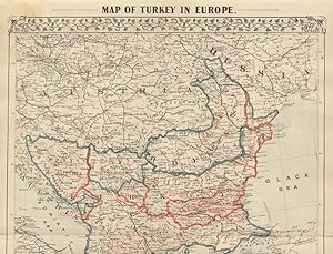
TURKEY IN EUROPE AN ANTIQUE MAP CIRCA 1860
Publicado por LONDON PRINTING AND PUBLISHING COMPANY, London, 1860
Librería: K Books Ltd ABA ILAB, York, YORKS, Reino Unido
Miembro de asociación: ABA ILAB PBFA
Valoración del vendedor:
Libro Original o primera edición
Single Sheet Engraving. Condición: Very Good. No Jacket. First Edition. TURKEY IN EUROPE, AN ANTIQUE MAP CIRCA 1860, A VERY GOOD MAP . VERY REASONABLY PRICED, . MEASURES 13 X 10 INCHES, ELABORATE BORDER, CIRCA 1860. DISPATCH WELL PACKED ROLLED IN A STRONG TUBE, VERY GOOD CONDITION, SPLENDID VALUE.
-
Map of Turkey - an Original Engraving
Librería: K Books Ltd ABA ILAB, York, YORKS, Reino Unido
Miembro de asociación: ABA ILAB PBFA
Valoración del vendedor:
Libro
No Binding. Condición: Very Good. A fine Engraving - printed circa 1870. Mounted and ready to frame. A fine opportunity to purchase an attractive and decorative engraved Map of Turkey.
-
Map of Turkey in Europe - an Original Engraving
Librería: K Books Ltd ABA ILAB, York, YORKS, Reino Unido
Miembro de asociación: ABA ILAB PBFA
Valoración del vendedor:
Libro
No Binding. Condición: Very Good. A fine Engraving - printed circa 1870. Mounted and ready to frame. A fine opportunity to purchase an attractive and decorative engraved Map of Turkey in Europe.
-
Map of Turkey & Hungary - an Original Antique Engraving
Ańo de publicación: 1820
Librería: K Books Ltd ABA ILAB, York, YORKS, Reino Unido
Miembro de asociación: ABA ILAB PBFA
Valoración del vendedor:
Libro
No Binding. Condición: Slight Crease. An original hand-coloured antique engraved map, printed circa 1820. Hand-colouring contemporary. Mounted/matted and ready to frame. A fine opportunity to purchase an attractive and decorative engraving of a Map of Turkey & Hungary - Asia.
-
Turkey and Northern Provinces - an Antique Map
Librería: K Books Ltd ABA ILAB, York, YORKS, Reino Unido
Miembro de asociación: ABA ILAB PBFA
Valoración del vendedor:
Libro
No Binding. Condición: Very Good. Engraved By Walker Ilustrador. A fine antique map in very good condition - printed in circa 1844. Mounted (matted) and ready to frame. Engraved size approx 16 x 13 Ins, 41 x 33 Cms. Mounted size approx 19 x 16 in, 49 x 41cm. Coloured in outline, hand colouring contemporary. A fine engraved map of Turkey and Northern Provinces.
-
Turkey, with North Part of Greece - an Antique Map
Librería: K Books Ltd ABA ILAB, York, YORKS, Reino Unido
Miembro de asociación: ABA ILAB PBFA
Valoración del vendedor:
Libro
No Binding. Condición: Very Good. Engraved By Walker Ilustrador. A fine antique map in very good condition - printed in circa 1844. Mounted (matted) and ready to frame. Engraved Size 14 x 10 Ins 35 x 25 cms. Mount size approx 17 x 13 ins, 43 x33 cms. Coloured in outline, hand colouring contemporary. A fine engraved map of Turkey, with North Part of Greece.
-
Turkey with Provinces in Asia Minor - an Antique Map
Librería: K Books Ltd ABA ILAB, York, YORKS, Reino Unido
Miembro de asociación: ABA ILAB PBFA
Valoración del vendedor:
Libro
No Binding. Condición: Very Good. Engraved By Walker Ilustrador. A fine antique map in very good condition - printed in circa 1844. Mounted (matted) and ready to frame. Engraved size approx 16 x 13 Ins, 41 x 33 Cms. Mounted size approx 19 x 16 in, 49 x 41cm. Coloured in outline, hand colouring contemporary. A fine engraved map of Turkey with Provinces in Asia Minor.
-
TURKEY IN EUROPE - An Original Antique Hand Coloured Map
Publicado por LONDON PRINTING, London, 1857
Librería: K Books Ltd ABA ILAB, York, YORKS, Reino Unido
Miembro de asociación: ABA ILAB PBFA
Valoración del vendedor:
Libro
No Binding. Condición: Very Good. Rapkin Ilustrador. A fine original antique hand coloured map, colouring not contemporary but delicately and expertly executed . . Mounted (matted) and ready to frame. Central fold otherwise very good condition. A splendid opportunity to acquire an antique original map - decorative, attractive and scarce . A splendid map of Turkey in Europe, with vignettes of Constantinople, Bosphorus, Ali Pasha etc with an inset map of Candia.
-
Turkey Map Antique Map
Ańo de publicación: 1790
Librería: K Books Ltd ABA ILAB, York, YORKS, Reino Unido
Miembro de asociación: ABA ILAB PBFA
Valoración del vendedor:
Libro
No Binding. Condición: Very Good. Antique map . Hand coloured, engraved map. mounted - matted - and ready to frame .12 x 10 inches. a vg copy of an attractive decorative hand coloured antique map. . A splendid map, colouring not contemporary but delicately and expertly done - a fine map of Turkey.
-
Map of Turkey - the Retreat of the Ten Thousand - Fine Detailed Map - an Original Engraving
Ańo de publicación: 1840
Librería: K Books Ltd ABA ILAB, York, YORKS, Reino Unido
Miembro de asociación: ABA ILAB PBFA
Valoración del vendedor:
Libro
No Binding. Condición: Very Good. A fine engraving - printed circa 1840. Mounted and ready to frame. Hand colouring not contemporary, but delicately and expertly executed. A fine opportunity to purchase an attractive and decorative engraving - Map of Turkey - the Retreat of the Ten Thousand.
-
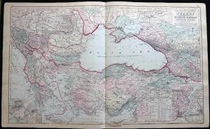
Original Double-Page Hand-Colored Gray's New Map of the Countries Surrounding the Black Sea, Comprising Turkey in Europe and Part of Turkey in Asia Greece (Hellas) Southern Russia Etc. By Frank Gray (and) Map of Russia (and) Map of France.
Publicado por O.W. Gray & Son, Philadelphia, PA, 1882
Librería: Certain Books, ABAA, Bolivia, NC, Estados Unidos de America
Miembro de asociación: ABAA ESA ILAB
Valoración del vendedor:

Original o primera edición
Not Bound. Condición: Very Good. Map. One sheet, printed with 3 maps, from the 1882 O.W. Gray National Atlas, New York Edition: Double-page Gray's New Map of the Countries Surrounding the Black Sea, Comprising Turkey in Europe and Part of Turkey in Asia Greece (Hellas) Southern Russia Etc. with inset map of the Environs of Athens and Piraeus and inset of The Bosphorus or Strait of Constantinople By Frank A. Gray with the copyright of 1879 O.W. Gray & Son (and) Russia (and) France, with inset map of Corsica. With original hand-coloring in pastel tones and outlining in red; Approx. 28 1/2" x 17 1/4" overall size; a little even toning to the paper, margin with a few little edge & tip-nicks, tip bend; in very good condition.
-
Turkey, with Southern Part of Greece and Candia - with Vignette of Athens - an Antique Map
Librería: K Books Ltd ABA ILAB, York, YORKS, Reino Unido
Miembro de asociación: ABA ILAB PBFA
Valoración del vendedor:
Libro
No Binding. Condición: Very Good. Engraved By Walker Ilustrador. A fine antique map in very good condition - printed in circa 1844. Mounted (matted) and ready to frame. Engraved size approx 16 x 13 Ins, 41 x 33 Cms. Mounted size approx 19 x 16 in, 49 x 41cm. Coloured in outline, hand colouring contemporary. A fine engraved map of Turkey, with Southern Part of Greece and Candia - with Vignette of Athens.
-
Map of Turkey in Europe Illustrating the Berlin Congress Treaty, July, 1878
Publicado por Mitchell's, Philadelphia, 1879
Librería: Main Street Fine Books & Mss, ABAA, Galena, IL, Estados Unidos de America
Miembro de asociación: ABAA ILAB MWABA
Valoración del vendedor:
Mapa
15" X 23Ľ" (image 14Ľ" X 20˝"). Printed coloring. Near fine. Single center fold (as issued). Attractive example of this large map bearing printed border coloring. Small inset at lower left features "A Map Showing the Relation of Cyprus to the Adjacent Coasts" and larger inset at lower left features "Map of Armenia to illustrate Articles 58, 59, 60 of the Treaty of Berlin." Quite interesting and in lovely condition.
-
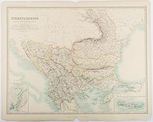
Turkey in Europe.with Rumania, Servia, Montenegro, Bulgaria &c.
Publicado por W. & A. K. Johnston, Edinburgh & London., 1893
Librería: Asia Bookroom ANZAAB/ILAB, Canberra, ACT, Australia
Miembro de asociación: ANZAAB ILAB
Valoración del vendedor:
Engraved map with original outline hand-colour, 44 x 57.4 cm (map), two inset maps of the Bosphorus and Crete; central fold, corners chipped with loss, lower edge with several small marginal tears, neatly repaired, head and foot clipped at the fold with loss to the margin, but the map in very good condition. Detailed and finely engraved map also showing submarine telegraph lines and relief by hachures. Re-issue of the map first published in 1863 for "Keith Johnston's Royal Atlas of Modern Geography".
-

Map of Turkey in Europe Together with the Ionian Islands
Publicado por Charles Desilver, Philadelphia, 1856
Librería: Main Street Fine Books & Mss, ABAA, Galena, IL, Estados Unidos de America
Miembro de asociación: ABAA ILAB MWABA
Valoración del vendedor:
Mapa
13 3/4" X 17Ľ" (image 9 3/4" X 12"). Hand colored. Near fine. Exceptionally clean and large-margined example of this lovely map. Lovely decorative border.
-
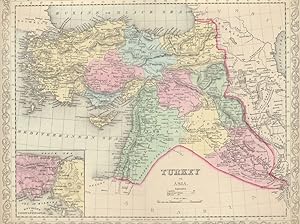
Turkey in Asia
Publicado por Charles Desilver, Philadelphia, 1856
Librería: Main Street Fine Books & Mss, ABAA, Galena, IL, Estados Unidos de America
Miembro de asociación: ABAA ILAB MWABA
Valoración del vendedor:
Mapa
17Ľ" X 13 3/4" (image 15" X 12Ľ"). Hand colored. Near fine. This bright, handsome example features a sharp inset at lower left showing "Environs of Constantinople" and nifty decorative border. Large, clean margins.
-
An Universal History from the Earliest Account of Time Compiled from Original Authors Volume VII
Publicado por Printed for T Osborne and Others, London, 1747
Librería: Robert S. Brooks, Bookseller, Bristol, WI, Estados Unidos de America
Valoración del vendedor:

Libro Original o primera edición
Hardcover. Condición: Fair Bookplate. Two Fold Out Maps ( Turkey, Armenia and Syria & Syria) One Fold Out Plate Ilustrador. 1st Edition. front cover loose but present, 591 pages.
-
The Seat of the War.
Librería: Henry Sotheran Ltd, London, Reino Unido
Miembro de asociación: ABA ILAB PBFA
Valoración del vendedor:
London, Mclure, Macdonald & Macgregor, Lithographers by Steam Power, 1854. Lithographic map c. 40 x 56cm), with a few places marked with dots in red, green and yellow; linen-backed at the time, one vertical fold, otherwise very good. 'Presented (as a Supplement) with the Derby Reporter, of Marck 17, 1854' (print in upper margin).