Importe total (1 artículo artículos):
Destino del pedido:

COLTON, GEORGE W (24 resultados)
Ir a los resultados principales
Tipo de artículo
- Todo tipo de artículos
- Libros (20)
- Revistas y publicaciones (1)
- Cómics
- Partituras
- Arte, grabados y pósters
- Fotografías
- Mapas (3)
-
Manuscritos y
coleccionismo de papel
Condición
Encuadernación
Más atributos
- Primera edición (3)
- Firmado
- Sobrecubierta
- Con imágenes del vendedor (13)
- Sin impresión bajo demanda (21)
Gastos de envío gratis
Ubicación del vendedor
Valoración de los vendedores
-

The Cumulative Loose-leaf Business Encyclopedia: Volume VI: Advertising, Correspondence, Office Management
Publicado por The John C. Winston Company, Chicago, 1934
Librería: Top Notch Books, Tolar, TX, Estados Unidos de America
Valoración del vendedor:

Hard Cover. Condición: Good. No Jacket. Set #A13143. Navy boards have light wear. Brad binding, pages faintly tanning, no markings in text. Size: 8vo - over 7ľ" - 9ľ" tall.
-
Bedrock Geology of the Waterville Quadrangle, Lycoming County, Pennsylvania [Progress Report PR 174]
Publicado por Commonwealth of Pennsylvania, Bureau of Topographic and Geologic Survey, Harrisburg, PA, 1968
Librería: Saucony Book Shop, Kutztown, PA, Estados Unidos de America
Valoración del vendedor:
Original o primera edición
Unbound. Condición: Near Fine. First Edition. Large color folding plate, with text, in original tan cardstock envelope. Complete as issued. Slight handling wear, virtually as issued; light crease to envelope. Size: 4to - over 9ľ" - 12" tall. Book.
-
Bedrock Geology And Surface Structure Of The Cedar Run Quadrangke, Tioga And Lycoming Counties, Pennsylvania
Publicado por Pennsylvania Geologic Survey, 1963
Librería: Willis Monie-Books, ABAA, Cooperstown, NY, Estados Unidos de America
Miembro de asociación: ABAA ESA ILAB
Valoración del vendedor:
Softcover. Condición: Very Good. In original envelope folder. ; Progress Report PR #164.
-
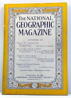
The National Geographic Magazine, Volume 98, Number 3 (September, 1950)
Publicado por National Geographic Society, Washington, 1950
Librería: Cat's Cradle Books, Archdale, NC, Estados Unidos de America
Valoración del vendedor:
Soft Cover. Condición: Good with no dust jacket. Sound binding. Pages clean, off-white. Wrappers have wear on spine, overall handling wear, soiling. Contents: Vosburgh, Flying in the "blowtorch" era. Long, Stewart, and Fletcher, Sea to lakes on the St. Lawrence. Palmer, Sisson and Fletcher, "Delmarva," gift of the sea. Colton, Mapping the unknown universe. ; 10.0" tall.
-

Daedalus: Journal of the American Academy of Arts & Sciences: Vol. 146, No. 2, Spring 2017: Russia Beyond Putin
Publicado por MIT Press, 2017
Librería: Armadillo Books, Chapel Hill, NC, Estados Unidos de America
Valoración del vendedor:

Revista / Publicación
Soft cover. Condición: Fine. Near mint condition! A crisp, bright, and tight copy -- no markings or defects of any kind. With articles by Maria Popova, Valerie Bunce, Henry E. Hale, Fiona Hill, Brian D. Taylor, Elena Chebankova, Marlene Laruelle, Stanislav Markus, Samuel A. Greene, Keith A. Darden, & George W. Breslauer. Ships quickly from NC. All journals are sealed in plastic, packed securely with protective cardboard backing, and shipped promptly with tracking. (C-5.).
-
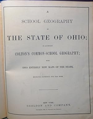
Colton and Fitch's Modern School Geography. Illustrated by . Maps, and . Engravings. by G. W. Fitch. Maps . by G. W. Colton. Revised Edition, Et
Publicado por British Library, Historical Print Editions, 2011
ISBN 10: 1240926472ISBN 13: 9781240926473
Librería: Lucky's Textbooks, Dallas, TX, Estados Unidos de America
Valoración del vendedor:
Libro
Condición: New.
Más opciones de compra de otros vendedores en IberLibro
Nuevo desde EUR 20,07
-
Colton and Fitch's Introductory School Geography
Publicado por Ivison, Phinney & Co., Chicago, 1863
Librería: Sea Chest Books, Tucumcari, NM, Estados Unidos de America
Valoración del vendedor:
Libro
Boards. Condición: Fair. Colton, G. Woolworth Ilustrador. Mid 19th century Geography book " Illustrated by Twenty Maps and Numerous Engravings". Owner name and other writing in ink on title page, and penmanship practice on final page and back pasted down endpaper. Cover has a red binding strip with tan illustrated boards, rounded corners of boards are chipped and worn, especially the bottom front and top back corners. Stain on front board with a few miscellaneous marks to front and back. Binding is tight, though glued down endpapers are split at the gutters. 98 pp. Education, Childrens, Antiquarian, Geography.
-
Colton and Fitch's Modern School Geography
Publicado por Legare Street Press 2021-09-09, 2021
ISBN 10: 1014321131ISBN 13: 9781014321138
Libro
Paperback. Condición: New.
-
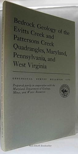
BEDROCK GEOLOGY OF THE EVITTS CREEK AND PATTERSONS CREEK QUADRANGLES, MARYLAND, PENNSYLVANIA AND WEST VIRGINIA Geological Survey Bulletin 1173
Publicado por Government Printing Office, Washington, D. C,, 1964
Librería: Nick Bikoff, IOBA, Fairfield, NJ, Estados Unidos de America
Miembro de asociación: IOBA
Valoración del vendedor:
Soft Cover. Condición: Very Good. Clean grey soft covers with black title. Text tight, clean & Intact. Illustrated with b/w photographs and four maps located in the rear pocket. Geology; Photographs & Maps; 8vo 8" - 9" tall; 91 pages.
-
![Imagen del vendedor de Colton & Fitch's primer of geography. Illus. by 16 maps, and numerous engravings [LeatherBound] a la venta por True World of Books](https://pictures.abebooks.com/inventory/md/md31533097493.jpg)
Colton & Fitch's primer of geography. Illus. by 16 maps, and numerous engravings [LeatherBound]
Ańo de publicación: 2023
Libro Impresión bajo demanda
LeatherBound. Condición: New. LeatherBound edition. Condition: New. Reprinted from 1864 edition. Leather Binding on Spine and Corners with Golden leaf printing on spine. Bound in genuine leather with Satin ribbon page markers and Spine with raised gilt bands. A perfect gift for your loved ones. NO changes have been made to the original text. This is NOT a retyped or an ocr'd reprint. Illustrations, Index, if any, are included in black and white. Each page is checked manually before printing. As this print on demand book is reprinted from a very old book, there could be some missing or flawed pages, but we always try to make the book as complete as possible. Fold-outs, if any, are not part of the book. If the original book was published in multiple volumes then this reprint is of only one volume, not the whole set. Sewing binding for longer life, where the book block is actually sewn (smythe sewn/section sewn) with thread before binding which results in a more durable type of binding. Pages: 90 Language: English.
-
![Imagen del vendedor de Colton and Fitch's introductory school geography [LeatherBound] a la venta por True World of Books](https://pictures.abebooks.com/inventory/md/md31533093859.jpg)
Colton and Fitch's introductory school geography [LeatherBound]
Ańo de publicación: 2023
Libro Impresión bajo demanda
LeatherBound. Condición: New. LeatherBound edition. Condition: New. Reprinted from 1858 edition. Leather Binding on Spine and Corners with Golden leaf printing on spine. Bound in genuine leather with Satin ribbon page markers and Spine with raised gilt bands. A perfect gift for your loved ones. NO changes have been made to the original text. This is NOT a retyped or an ocr'd reprint. Illustrations, Index, if any, are included in black and white. Each page is checked manually before printing. As this print on demand book is reprinted from a very old book, there could be some missing or flawed pages, but we always try to make the book as complete as possible. Fold-outs, if any, are not part of the book. If the original book was published in multiple volumes then this reprint is of only one volume, not the whole set. Sewing binding for longer life, where the book block is actually sewn (smythe sewn/section sewn) with thread before binding which results in a more durable type of binding. Pages: 92 Language: English.
-
![Imagen del vendedor de Colton and Fitch's modern school geography [LeatherBound] a la venta por True World of Books](https://pictures.abebooks.com/inventory/md/md31533101221.jpg)
Colton and Fitch's modern school geography [LeatherBound]
Ańo de publicación: 2023
Libro Impresión bajo demanda
LeatherBound. Condición: New. LeatherBound edition. Condition: New. Reprinted from 1886 edition. Leather Binding on Spine and Corners with Golden leaf printing on spine. Bound in genuine leather with Satin ribbon page markers and Spine with raised gilt bands. A perfect gift for your loved ones. NO changes have been made to the original text. This is NOT a retyped or an ocr'd reprint. Illustrations, Index, if any, are included in black and white. Each page is checked manually before printing. As this print on demand book is reprinted from a very old book, there could be some missing or flawed pages, but we always try to make the book as complete as possible. Fold-outs, if any, are not part of the book. If the original book was published in multiple volumes then this reprint is of only one volume, not the whole set. Sewing binding for longer life, where the book block is actually sewn (smythe sewn/section sewn) with thread before binding which results in a more durable type of binding. Pages: 140 Language: English.
-
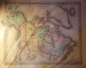
Original Map - "Northern America: British, Russian and Danish Possessions in North America" and One Accompanying Page from Colton's Atlas of the World (1857)
Publicado por J. H. Colton and Company, New York, 1857
Librería: Barry Cassidy Rare Books, Sacramento, CA, Estados Unidos de America
Valoración del vendedor:
Libro
No Binding. Condición: Collectible-Very Good. Original hand-colored, engraved map showing Canada, the upper portion of the U.S., Greenland, Iceland, and part of Asia. Map has beautifully-rendered pink, yellow, and blue watercoloring to illustrate which territories were claimed by Britain, Denmark, and Russia, respectively. Map with margins measures 18 3/8" x 15 1/2"; actual map area measures 11 1/4" x 14 1/4." Clean and intact map with very little foxing mostly limited to the margins. Beautiful black and white decorative scrollwork border around the map, which is commonly found on Colton maps. Title at the top. "No. 3" printed in lower-right corner. The one leaf of text measures 15 1/2" x 18 3/8" and includes descriptions of Russian, Danish, and British North America (text continues onto another page that is not included). This map and accompanying page of text originally appeared in Colton's Atlas of the World, Illustrating Physical and Political Geography by George W. Colton; Accompanied by Descriptions Geographical, Statistical, and Historical by Richard Swainson Fisher; Volume I--North and South America, Etc. (1857). While this map comes from the 1857 edition, the 1856 first edition was G. W. Colton's first atlas published and one of the most accurate of its time. Joseph H. Colton (1800-1893) founded J. H. Colton and Company which was a leading mapmaking company in the international cartography industry. Joseph Colton employed some of the preeminent cartographers and map engravers of the time. His sons, George W. Colton (1827-1901) and Charles B. Colton (1832-1916) later joined the company.
-
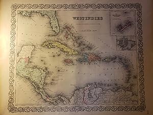
Original Map - "West Indies" and Five Accompanying Pages from Colton's Atlas of the World (1857)
Publicado por J. H. Colton and Company, New York, 1857
Librería: Barry Cassidy Rare Books, Sacramento, CA, Estados Unidos de America
Valoración del vendedor:
Mapa
No Binding. Condición: Collectible-Fine. Original publisher's hand-colored map of the West Indies with five original accompanying pages from Colton's Atlas of the World Illustrating Physical and Political Geography by George W. Colton; Accompanied by Descriptions Geographical, Statistical, and Historical by Richard Swainson Fisher; Volume I.--North and South America, Etc. (1857). A beautiful map with pink, yellow, blue, orange, and green watercoloring. The accompanying pages of text include descriptions of the West Indies that explain the region's history, culture, and geography. Map with margins measures 18 1/2" x 15 1/2"; actual map area is 14 1/8" x 11 1/4"; each of the five pages of text measures 15 1/2" x 18 1/2." The map and pages are very clean and intact and are fine copies. The map is labeled as No. 56 in the lower-right corner. Decorative scrollwork border included which is commonly found on J. H. Colton's maps. Lines of latitude and longitude also included. Lower-left corner of map area includes publication information. Printed underneath the title (approximately top-center) is the scale of distance in miles and the following information: "Published by J. H. Colton & Co., No. 172 William St., New York." This map shows the islands of the Greater and Lesser Antilles, such as Cuba, Jamaica, Haiti, the Dominican Republic, Puerto Rico, and the Windward and Leeward Islands. Parts of Mexico, Honduras, Nicaragua, Panama, Colombia, Venezuela, and Florida are also shown. Two smaller maps within the map area show the Bermuda Islands and the city and harbor of Havana. Major cities, rivers, and other geographical features are included as well as the Gulf of Mexico, Pacific Ocean, Atlantic Ocean, and the Caribbean Sea. While this map comes from the 1857 edition atlas, the 1856 first edition was G. W. Colton's first atlas published and one of the most accurate of its time. Joseph H. Colton (1800-1893) founded J. H. Colton and Company which was a leading mapmaking company in the international cartography industry. Joseph Colton employed some of the preeminent cartographers and map engravers of the time. His sons, George W. Colton (1827-1901) and Charles B. Colton (1832-1916) later joined the company.
-
Colton's Common School Geography
Publicado por Sheldon & Co., NY, 1879
Librería: Peter Austern & Co. / Brooklyn Books, Brooklyn, NY, Estados Unidos de America
Miembro de asociación: ESA
Valoración del vendedor:
Hardcover. Condición: Good. NY: Sheldon & Co., 1879. Textbook. Good. Hardcover. Folio - over 12. Approx. 10.5x12 inches. illustrated by numerous engravings and twenty-two study maps, drawn expressly for this work, and specially adapted to the wants of the classroom. To which are added two full-paged railroad maps, showing the chief routes of travel, and a complete series of twelve commercial and reference maps of the United States. Small folio, 153 pages, colored. maps. Brown embossed boards, worn, hinges split. Ohio edition. One of best of the era's geographies, Housed in a protective custom box. Textbook.
-
Colton and Fitch's Modern School Geography. Illustrated By Forty Maps and Numerous Engravings
Publicado por J. H. Colton and Company, New York, 1856
Librería: Voyageur Book Shop, Milwaukee, WI, Estados Unidos de America
Valoración del vendedor:
Libro
Hardcover. Condición: Fair. Estado de la sobrecubierta: No Dust Jacket. 124pp. Paper covered hardcover with red leather spine, boards heavily chipped, much of the cover paper and endpapers missing. Stains, soiling, and children's doodles found throughout the book. Numerous colored maps, binding sound. Size: 4to - over 9ľ" - 12" tall J1.
-
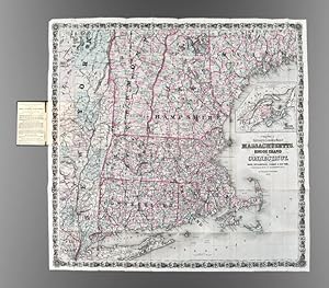
Colton's Railroad & Township Map of Massachusetts, Rhode Island, Connecticut with parts of Maine, New Hampshire, Vermont & New York
Publicado por G.W. & C.B. Colton, New York, 1876
Librería: Donald A. Heald Rare Books (ABAA), New York, NY, Estados Unidos de America
Miembro de asociación: ABAA ILAB
Valoración del vendedor:
Mapa
Folding pocket map, full period hand coloring. Inset of the British Provinces on the Gulf of St. Lawrence. Folds into publisher's blindstamped cloth covers, title stamped in gilt in the upper cover, Colton ad on the front pastedown. Large and colorful Colton map of New England. This decorative map depicts the region from New York City in the southwest corner to Searsmont, Maine in the northeast corner, with the Saranac Lakes in the northwest corner. Both counties and townships are identified, with many towns named. Roads, waterways and railroads are all shown.
-
GEORGE W. Colton. JM COLTON AND COMPANY: Nueva York 1856. Media piel con nervios y dorados. Encuadernación casera. Probablemente contiene mapas de ambos tomos (son dos). Incluye 100 mapas a toda página sin orden entre lámina. Sin paginar. Algunas hojas están rajadas. Texto en inglés a tres columnas. Tamańo: 43.5 x 37 cm. Falto de portada e índice. Incluye entre otros: Cotton s Louisiana, The State of New York, Canadá, Virginia, Bastern Hemisphere. Puntos de óxido. (SAN JOSÉ) ATLAS.
-
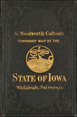
G. W. Colton's Township Map of the State of Iowa
Publicado por G.W. & C.B. Colton, New York, 1869
Librería: Donald A. Heald Rare Books (ABAA), New York, NY, Estados Unidos de America
Miembro de asociación: ABAA ILAB
Valoración del vendedor:
Mapa
Folding pocket map, full period hand-colouring, ornamental border. Census table at lower right. Folds into publisher's blindstamped cloth covers, title stamped in gilt on the upper cover, Colton ad on the front pastedown. Colton pocket map of Iowa. Iowa experienced explosive growth during the 1860s, largely as a result of the rapid development of the state's railroad system. At the beginning of the decade, Iowa's few railroads were entirely confined to the eastern one-third of the state. By the time Colton published this fine map in 1869, several lines had pushed to its western border, including the Mississippi & Missouri Railroad, which joined the transcontinental railroad at Council Bluffs. This map is similar to another one published by the Coltons in the same period, though smaller and without the "sectional" divisions. Rumsey 0180 (1855 issue); Phillips, A List of Maps of America, p. 337 (1862 issue).
-
Atlas of the World Vol 2
Publicado por Colton & Company, New York, 1856
Librería: Manning's Books & Prints, ABAA, Pacifica, CA, Estados Unidos de America
Miembro de asociación: ABAA ILAB
Valoración del vendedor:

Libro
Hardcover. Condición: Very Good. contains 36 engraved maps. hand colored. Very good condition.
-
Colton's Atlas of the World (Vol. 2 Only)
Publicado por J.H. Colton & Co., New York, 1856
Librería: Abacus Bookshop, Pittsford, NY, Estados Unidos de America
Valoración del vendedor:
Original o primera edición
hardcover. Profusely illustrated Ilustrador. 1st edition. Folio, Backstrip partially detached; rear board detached; bookblock intact, Second volume of a two volume set with 49 maps (some double plates, some hand-colored) of Europe, Asia, Africa & Oceania. Previous owner has lightly stamped his name in the margins of the plates, not affecting the images. No foxing. Binding poor, contents very good.
-
Colton's Map of the New York Wilderness
Publicado por New York: G.W and C.B. Colton and Co., 1872., 1872
Librería: Arader Galleries - AraderNYC, New York, NY, Estados Unidos de America
Valoración del vendedor:
Single sheet (29 4/8 x 29 inches). 15-pages text. Fine lithographed map with original hand-colour in full, surrounded by an elaborate border of scallop shells and acanthus leaves. Original publisher's black cloth, gilt. "The New York Wilderness embraces a large part of the northern portion of the State - being about seventy-five miles in extent from east to west and from north to south. The southern portion of Clinton, Franklin, and St. Lawrence Counties, nearly all of the Hamilton and Warren Counties, and parts of Essex, Herkimer, and Lewis Counties are comprised in this territory. The wild and rugged character of the Wilderness, the grandeur of its mountain scenery, the beauty of its lakes, rivers, and forests, have made it one of the most popular resorts in our country; while invalids bear favorable testimony to the efficacy of its pure, bracing air, and the excitements incident to travel and life in the woods" (pages [1] -3). Joseph Hutchins Colton had begun publishing maps in New York in the 1830s. Between 1831 and 1890, the Colton firm dominated American map publishing, although Colton had no formal training in geography or cartography; he began by purchasing copyrights of maps prepared by other individuals or companies, and his principal role was to manage the production and distribution of the maps. His first maps were drawn by the esteemed cartographer David H. Burr in the 1830s. By the 1850s Colton was also publishing guidebooks, atlases and immigrant and railroad maps. The firm was renamed G.W. & C.B. Colton in the 1860s when Colton was succeeded by his sons, George and Charles.
-
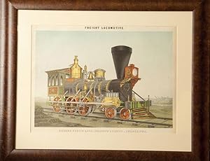
CHROMOLITHOGRAPH OF A "FREIGHT LOCOMOTIVE. RICHARD NORRIS & SON, LOCOMOTIVE BUILDERS, PHILADELPHIA."
Publicado por 1855., 1855
Librería: BUCKINGHAM BOOKS, ABAA, ILAB, IOBA, GREENCASTLE, PA, Estados Unidos de America
Miembro de asociación: ABAA ILAB IOBA RMABA
Valoración del vendedor:
Original o primera edición
First edition. 16 5/8" x 11 3/4' lithograph image, matted and framed to a 25 1/4" x 21" total size. In 1856, J. H. Colton & Co., issued a Philadelphia commercial edition of its ATLAS OF AMERICA, on the cover of which was stamped "Colton's Atlas With Business Cards of the Prominent Houses in Philadelphia, Commercial Edition." This was an atlas in which the Colton firm sold different size advertisements to be placed within the atlas, so that among the fine maps of North and South America which appeared in all their atlases, this version included numerous advertisements for Philadelphia business firms. Among these was this colorful lithograph of a freight locomotive built by Richard Norris and Son Company of Philadelphia. The freight engine is owned by the Ohio-Indiana Railroad, whose name is positioned in front of the cab. The company's name appears twice on the engine. The print was lithographed by L. Haugg, and printed in color by A. Brett. While the imposing freight locomotive dominates the picture, to the right and in the background is a view of the Norris & Company factory. A bright, colorful, and imposing image of the freight locomotive makes this a highly desirable train print of the leading and largest locomotive manufacturer in the United States, if not the world, during the 1850s. Fine.