
Importe total (1 artículo artículos):
Destino del pedido:

CO , G W BACON & (76 resultados)
Ir a los resultados principales
Tipo de artículo
- Todo tipo de artículos
- Libros (55)
- Revistas y publicaciones
- Cómics
- Partituras
- Arte, grabados y pósters
- Fotografías
- Mapas (21)
-
Manuscritos y
coleccionismo de papel
Condición
Encuadernación
Más atributos
- Primera edición (15)
- Firmado
- Sobrecubierta
- Con imágenes del vendedor (49)
- Sin impresión bajo demanda (67)
Gastos de envío gratis
Ubicación del vendedor
Valoración de los vendedores
-
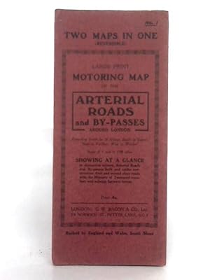
Reversible Large Print Motoring Map No.1: Arterial Roads and England & Wales: South Sheet
Publicado por G.W. Bacon & Co. Ltd, 1111
Librería: World of Rare Books, Goring-by-Sea, SXW, Reino Unido
Valoración del vendedor:

Condición: Fair. No Edition Remarks. Unpaginated. Red paper cover. Colour illustrated reversible map. Number 1: Arterial Roads and By-Passes, 1 inch to 1.08 miles; and England & Wales, South Sheet, 8 miles to 1 inch. Map is lightly tanned with some mild rubbed marks overall. Scuffing along folds, with some heavier tanning. Some moderate tears to folds along edges. Paper cover has mild edge wear with scuffing to edges and creasing. Mild rubbing to surfaces with curling to corners.
-

Bacon's County Map Of Yorkshire
Publicado por G W Bacon & Co, 1111
Librería: World of Rare Books, Goring-by-Sea, SXW, Reino Unido
Valoración del vendedor:
Condición: Good. Unpaginated. Green pictorial paperback. Map is bright and clear with some light foxing and tanning. Slight creases to corners.
-
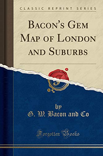
Bacon's Gem Map of London and Suburbs (Classic Reprint)
Publicado por Forgotten Books, 2018
ISBN 10: 1528403932ISBN 13: 9781528403931
Librería: PBShop.store US, Wood Dale, IL, Estados Unidos de America
Valoración del vendedor:
Libro
PAP. Condición: New. New Book. Shipped from UK. Established seller since 2000.
Más opciones de compra de otros vendedores en IberLibro
Nuevo desde EUR 15,64
-
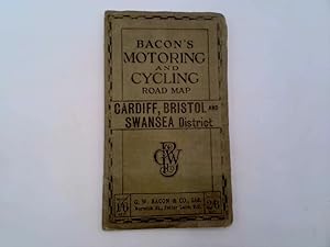
Bacon's Motoring and Cycling Road Map - Cardiff, Bristol and Swansea District
Publicado por G. W. Bacon & Co. Ltd.
Librería: Goldstone Rare Books, Llandybie, CARMS, Reino Unido
Valoración del vendedor:
Cloth. Condición: Good. Photograph available on request.
-

Bacon's Gem Map Of London And Suburbs
Publicado por LEGARE STREET PR, 2022
ISBN 10: 1017771979ISBN 13: 9781017771978
Librería: PBShop.store US, Wood Dale, IL, Estados Unidos de America
Valoración del vendedor:
Libro Impresión bajo demanda
PAP. Condición: New. New Book. Shipped from UK. THIS BOOK IS PRINTED ON DEMAND. Established seller since 2000.
Más opciones de compra de otros vendedores en IberLibro
Nuevo desde EUR 18,26
-

Bacon's large-print (5 miles to 1 inch) motor map: the Midlands (sheet 5 of England)
Publicado por G. W. Bacon, London, 1925
Librería: Cotswold Internet Books, Cheltenham, Reino Unido
Valoración del vendedor:
Undated - c.1925. Linen backed folding map in limp cloth cover. Map clean, but most of index at front missing (staples had rusted, leaving stain); cover a little worn Used - Acceptable. Fair folded map in card cover.
-
![Imagen del vendedor de Bacon's motoring and cycling road map : London and West District [vintage road map, ca. 1913] a la venta por MW Books](https://pictures.abebooks.com/inventory/md/md14221203905.jpg)
Bacon's motoring and cycling road map : London and West District [vintage road map, ca. 1913]
Publicado por London : G. W. Bacon & Co., ca. 1913, 1913
Librería: MW Books, New York, NY, Estados Unidos de America
Valoración del vendedor:
Original o primera edición
First Edition. Fair to good copy bound in title-printed, stiff-card wrappers, somewhat edge-worn as with age. Previous owner's signature on front cover. The map in a good condition, slightly faded with some dulling and minor tears around the edges. Further scans, images etc. and additional bibliographical material available on request. ; 8vo 8" - 9" tall; 13 pages; Vintage fold-out colour road map. Folds into booklet form, with added content in 13 pages featuring advertisements, indexes, route and distance tables etc. 17 x 10cm. Map folds out to 75 x 54cm. Subjects: Vintage maps -- London -- Great Britain -- Cycling routes -- Motoring routes. Suggested publication date taken from one of the advertisements. 1 Kg.
-
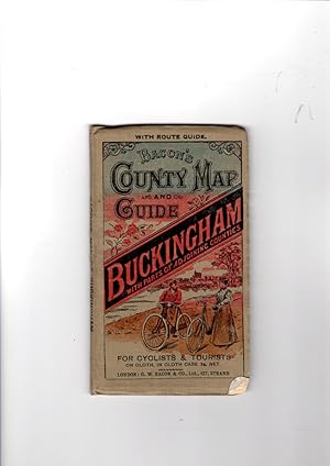
Bacon's County Map and Guide. Buckingham with parts of adjoining counties, for cyclists and tourist, on cloth, in cloth case.
Publicado por G. W. Bacon & Co., London
Librería: Gwyn Tudur Davies, Aberystwyth, Reino Unido
Valoración del vendedor:
Mapa
Soft cover. Condición: Good. No Jacket. i folded col. map on cloth and 16 page guide. No publishing date present, c. 1910. Covers rather dulled and one minor annotation on verso of map o/w a very clean copy in good condition. Ref m28.
-
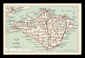
Post card showing a map of the Isle of Wight
Publicado por Edinburgh: G. W. Bacon & Co. Ltd.
Librería: MW Books, New York, NY, Estados Unidos de America
Valoración del vendedor:
Original o primera edición
First Edition. One postcard in near fine condition and printed on stiff card paper. Remains well preserved overall; bright and clean. No inscription on the back of the postcard. Physical description; 1 postcard. Notes; No clear date given. Subjects; Isle of Wight. Maps. Postcards. 1 Kg.
-
Bacon's county map and guide: Gloucester with parts of adjoining counties
Publicado por G. W.Bacon, London, 1910
Librería: Cotswold Internet Books, Cheltenham, Reino Unido
Valoración del vendedor:
Undated - c.1910. Map clean & untorn, with light foxing on one fold. Used - Good. Good folded map in card cover.
-
![Imagen del vendedor de Bacon's motoring and cycling road map : London and West District [vintage road map, ca. 1913] a la venta por MW Books Ltd.](https://pictures.abebooks.com/inventory/md/md14271410484.jpg)
Bacon's motoring and cycling road map : London and West District [vintage road map, ca. 1913]
Publicado por London : G. W. Bacon & Co., ca. 1913, 1913
Original o primera edición
First Edition. Fair to good copy bound in title-printed, stiff-card wrappers, somewhat edge-worn as with age. Previous owner's signature on front cover. The map in a good condition, slightly faded with some dulling and minor tears around the edges. Further scans, images etc. and additional bibliographical material available on request. ; 8vo 8" - 9" tall; 13 pages; Vintage fold-out colour road map. Folds into booklet form, with added content in 13 pages featuring advertisements, indexes, route and distance tables etc. 17 x 10cm. Map folds out to 75 x 54cm. Subjects: Vintage maps -- London -- Great Britain -- Cycling routes -- Motoring routes. Suggested publication date taken from one of the advertisements. 1 Kg.
-
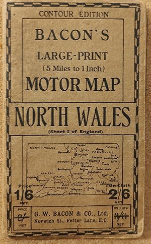
Bacon's Large-print (5 Miles to 1 Inch) Motor Map - North Wales (Sheet 2 of England) CONTOUR EDITION
Publicado por G W Bacon & Co Ltd, 1950
Mapa
Soft cover. Condición: Very Good. (SL#19).
-
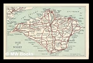
Post card showing a map of the Isle of Wight
Publicado por Edinburgh: G. W. Bacon & Co. Ltd.
Original o primera edición
First Edition. One postcard in near fine condition and printed on stiff card paper. Remains well preserved overall; bright and clean. No inscription on the back of the postcard. Physical description; 1 postcard. Notes; No clear date given. Subjects; Isle of Wight. Maps. Postcards. 1 Kg.
-
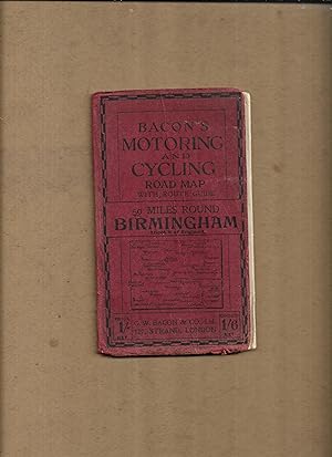
Bacon's motoring and cycling road map with route guide, 50 miles round Birmingham, Sheet8 of England. (Bacon's half-inch maps)
Publicado por G.W. Bacon & Co. Ltd
Librería: Gwyn Tudur Davies, Aberystwyth, Reino Unido
Valoración del vendedor:
Mapa
Soft cover. Condición: Good. No Jacket. 1 folded col. map. Covers dulled and creased, some scuffing along folds of map o/w pretty good condition. No publication date [c191-?]. [Maps - Birmingham and district - England] r390 / m14101.
-
Bacon's Up-To-Date Map London
Publicado por G W Bacon & Co, 1926
Librería: Mark Henderson, Olathe, KS, Estados Unidos de America
Valoración del vendedor:

Hardcover. Condición: Very Good. No date circa 1926. References a post office sorting center that opened in 1926. Book.
-
Bacon's Gem Map of London and Suburbs (Classic Reprint)
Publicado por Forgotten Books, 2018
ISBN 10: 0266975437ISBN 13: 9780266975434
Librería: PBShop.store US, Wood Dale, IL, Estados Unidos de America
Valoración del vendedor:
Libro
HRD. Condición: New. New Book. Shipped from UK. Established seller since 2000.
Más opciones de compra de otros vendedores en IberLibro
Nuevo desde EUR 28,73
-
Bacon's Motoring and Cycling Road Map - Nottingham District - Half Inch Series.
Publicado por G.W. Bacon & Co. Ltd, United Kingdom, 1920
Librería: Winghale Books, South Kelsey, LINCS, Reino Unido
Valoración del vendedor:
Libro
Soft cover. Condición: Read description. Size (folded) - 18 x 10 cms. Size (unfolded) - 90 x 65 cms. No date but probably early 20th Cent. Covers and rear of map stained - the stain mark is also around the edges of the front idex (a large browning type mark) - a few minor tears to map - see photo. Bacon's Motoring and Cycling Road Map - Nottingham District - Half Inch Series. - no date but probably 1920s/30s?).
-
![Imagen del vendedor de Bacon's gem-map of London and suburbs. (1919) [LeatherBound] a la venta por S N Books World](https://pictures.abebooks.com/inventory/md/md30962648255.jpg)
Bacon's gem-map of London and suburbs. (1919) [LeatherBound]
Ańo de publicación: 2022
Libro Impresión bajo demanda
LeatherBound. Condición: New. Leather Binding on Spine and Corners with Golden leaf printing on spine. Bound in genuine leather with Satin ribbon page markers and Spine with raised gilt bands. A perfect gift for your loved ones. Reprinted from 1919 edition. NO changes have been made to the original text. This is NOT a retyped or an ocr'd reprint. Illustrations, Index, if any, are included in black and white. Each page is checked manually before printing. As this print on demand book is reprinted from a very old book, there could be some missing or flawed pages, but we always try to make the book as complete as possible. Fold-outs, if any, are not part of the book. If the original book was published in multiple volumes then this reprint is of only one volume, not the whole set and contains approximately 38 pages. IF YOU WISH TO ORDER PARTICULAR VOLUME OR ALL THE VOLUMES YOU CAN CONTACT US. Resized as per current standards. Sewing binding for longer life, where the book block is actually sewn (smythe sewn/section sewn) with thread before binding which results in a more durable type of binding. Language: English.
-
![Imagen del vendedor de Bacon's gem map of London and suburbs [LeatherBound] a la venta por True World of Books](https://pictures.abebooks.com/inventory/md/md31534449863.jpg)
Bacon's gem map of London and suburbs [LeatherBound]
Ańo de publicación: 2023
Libro Impresión bajo demanda
LeatherBound. Condición: New. Leather Binding on Spine and Corners with Golden leaf printing on spine. Bound in genuine leather with Satin ribbon page markers and Spine with raised gilt bands. A perfect gift for your loved ones. Reprinted from 1900 edition. NO changes have been made to the original text. This is NOT a retyped or an ocr'd reprint. Illustrations, Index, if any, are included in black and white. Each page is checked manually before printing. As this print on demand book is reprinted from a very old book, there could be some missing or flawed pages, but we always try to make the book as complete as possible. Fold-outs, if any, are not part of the book. If the original book was published in multiple volumes then this reprint is of only one volume, not the whole set and contains approximately 44 pages. IF YOU WISH TO ORDER PARTICULAR VOLUME OR ALL THE VOLUMES YOU CAN CONTACT US. Resized as per current standards. Sewing binding for longer life, where the book block is actually sewn (smythe sewn/section sewn) with thread before binding which results in a more durable type of binding. Language: English.
-

Bacon's Gem Map Of London And Suburbs
Publicado por LEGARE STREET PR, 2022
ISBN 10: 1017766517ISBN 13: 9781017766516
Librería: PBShop.store US, Wood Dale, IL, Estados Unidos de America
Valoración del vendedor:
Libro Impresión bajo demanda
HRD. Condición: New. New Book. Shipped from UK. THIS BOOK IS PRINTED ON DEMAND. Established seller since 2000.
Más opciones de compra de otros vendedores en IberLibro
Nuevo desde EUR 32,61
-
Bacon's New Large Print Map of London and Suburbs : Extending From Highgate to Wimbledon, Twickenham to Greenwich
Publicado por London: G.W. Bacon & Co., 1939
Librería: Sequitur Books, Boonsboro, MD, Estados Unidos de America
Miembro de asociación: IOBA
Valoración del vendedor:
Libro
Hardcover. Condición: Very Good. 40 p. : maps ; 19 cm. Bound in publisher's green cloth. Black lettering on front cover and spine. Good binding and cover. Minimal shelfwear. Slight sunning to spine and extremities. Clean, unmarked pages with minimal tanning. Map detached.
-
Bacon's New Large Print Map of London and Suburbs
Publicado por G.W. Bacon & Co. Ltd.
Librería: Wonder Book, Frederick, MD, Estados Unidos de America
Miembro de asociación: ABAA ILAB
Valoración del vendedor:
Condición: Good. Good condition. No date stated. Circa 1940. (Street Map, Tourist Guide, Landmarks).
-
Bacon's Motoring and Cycling Road Map: Birmingham District
Publicado por G. W. Bacon & Co. Ltd., London, 1915
Librería: Besleys Books PBFA, Diss, Reino Unido
Miembro de asociación: PBFA
Valoración del vendedor:
Hard Cover. Condición: Good. Hardback, folding map measuring 64cm x 89cm. Tear with small loss to 8pp Index of Towns. Map is in good order. A decent copy. (ar18).
-
The Metropolitan Borough of Holborn.
Publicado por , 1939, 1939
Librería: Pennymead Books PBFA, Knaresborough, Reino Unido
Miembro de asociación: PBFA
Valoración del vendedor:
Lithograph, coloured. Scale 1: 2500. Large folding map in fine condition. 39 x 31" Drawn by J.E. Parr Borough Engineer and Surveyor.
-
![Imagen del vendedor de Bacon's large print map of London and suburbs [cartographic material]. a la venta por In 't Wasdom - antiquariaat Cornelissen & De Jong](https://pictures.abebooks.com/inventory/md/md31619480910.jpg)
Bacon's large print map of London and suburbs [cartographic material].
Publicado por G.W. Bacon & Co. n.d. [1948], London, 1948
Librería: In 't Wasdom - antiquariaat Cornelissen & De Jong, Notter, Holanda
Valoración del vendedor:
Libro
Condición: Good. Goed. Gebonden, 40 pp. Uit de collectie van Igor Cornelissen, large print map of London and suburbs Bacon's large-print map of London and suburbs with guide. Large-print map of London and suburbs with guide Strangers' guide to London (introduction, 16 pp. + index to streets 24 pp.), sent as letter.
-
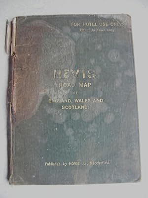
Hovis Road Map of England, Wales & Scotland
Publicado por Hovis Ltd, Macclesfield, 1920
Original o primera edición
Condición: Poor. G W Bacon & Co Ltd. London Ilustrador. First. HB no date circa 1920s believed 1st Ed. thus. Green cloth boards. Gilt tiltes + info front & back. Hotel copy as stated front cover top right. Colour maps. 25 x 18.3cm. 31 pages of maps + 4 pages at the end clarifying the difference between Hovis and brown bread. Frontis period Hovis advert. Small sepia illustrations of the principal Hovis mills and works. Ends with a Special Notice, that if any reader wishes to vist any Hovis Mill or Works to show this copy to a manager and that confirms a free pass. Condition: Tired and used! Front cover big stain on front, further discolouration marks + very small holes as if a compass has been inserted. Spine cracked, webbing showing. Wear on all edges. o/p stain seeped through to P2. 1st paste down has red crayon line grid + numbers. Following title page light pencil annotation + loose. Binding only just holding to P1. From P1 onwards binding secure from top to centre of pages, loose below this. Pages tanned + marks on margin edges. P20 ripped diagonally from top left to bottom right + crinkled at bottom right. Last page of Hovis mills loose + stain in seam. Although cover lets it down badly and opening pages arent great, maps clear. For its age and obvious use, surprising its still around!.
-
Bacon's Excelsior Map of Lincolnshire and Parts of Adjoining Counties. Showing Railways, Roads, Elevations & Distances; also Local Government Divisions. Revised According to the Latest Ordnance Survey.
Publicado por Manchester: G W Bacon c, 1900
Librería: David Ford Books PBFA, Cley-next-the-Sea, Reino Unido
Miembro de asociación: PBFA
Valoración del vendedor:
Mapa
Condición: very good. Undated but from style and contents probably c.1900. HB. Purple cloth covers, lettered in gilt to spine and front, protecting large coloured folding map printed on paper laid onto linen, with marbled paper front and back once folded. Folds out to 25 sections. Scale of 2 miles to one inch. Folded size: 23 x 19 cm, opening out to 115 x 92 cm. Attractively printed in various colours, (pink, orange, green and yellow), with a panel devoted to geology map, as well as text panels at sides for Index-Gazetteer. Copyright John Bartholomew. Good+ condition overall: the map is very good, bright and mostly clean, with slight browning to margins, some small dark brown marks to lower margin; the back of linen is grubby and marked. The cloth covers are fair, worn and with faded and marked margins, and with frayed cloth to spine; gilt to front is still bright. Other Bacon maps of various counties published at same time in same format available.
-
Bacon's New Survey Map of Staffordshire and Shropshire. Showing Railways, Roads, Elevations & Distances; also Local Government Divisions and Parishes. Revised According to the Latest Ordnance Survey.
Publicado por Manchester: G W Bacon c, 1900
Librería: David Ford Books PBFA, Cley-next-the-Sea, Reino Unido
Miembro de asociación: PBFA
Valoración del vendedor:
Mapa
Condición: Very Good. Undated but from style and contents probably c.1900. HB. Purple cloth covers, lettered in gilt to spine and front, protecting large coloured folding map printed on paper laid onto linen, with marbled paper front and back once folded. Folds out to 25 sections. Scale of 2 miles to one inch. Folded size: 23 x 19 cm, opening out to 115 x 92 cm. Attractively printed in various colours, with a panel devoted to geology map, as well as text panels at sides for Index-Gazetteer. Copyright John Bartholomew. Very Good condition, the map is bright and clean, with slight slight browning to margins, and the folds are clean and sturdy. The cloth covers have some fading and browning around spine, with some fraying to cloth at edges.
-
Bacon's New Survey Map of South Scotland including Counties of Dumbarton, Stirling. (etc) Showing Burghs, Parishes, Railways, Roads, Elevations & Distances.
Publicado por Manchester: G W Bacon c, 1900
Librería: David Ford Books PBFA, Cley-next-the-Sea, Reino Unido
Miembro de asociación: PBFA
Valoración del vendedor:
Mapa
Condición: very good. Undated but from style and contents probably c.1900. HB. Purple cloth covers, lettered in gilt to spine and front, protecting large coloured folding map printed on paper laid onto linen, with marbled paper front and back once folded. Folds out to 24 sections. Scale of 3 miles to one inch. Folded size: 24.5 x 21 cm, opening out to 95 x 120 cm. Attractively printed in various colours, (pink, yellow, light orange and green), with a panel devoted to geology map, as well as text panels at sides for Index-Gazetteer. Good condition overall: the map is very good, bright and clean, with slight browning to margins, and the folds are clean and sturdy; there are some light marks to back of linen. The cloth covers are fair only as spine panel is largely lost but the front is very good and with bright gilt of title; creases to back. Other Bacon maps of various counties published at same time in same format available.
-
Bacon's New Large Print Map of London and Suburbs
Librería: Celler Versandantiquariat, Eicklingen, Alemania
Miembro de asociación: GIAQ
Valoración del vendedor:
Libro
Selbstverlag, London, (um 1947). 1 farbige mehrfach gefaltete Karte mit 40 seitigen Beiheft Strangers' Guide to London, auf Leinen gezogen, scale 2 - 3 inches = 1 mile/ Maße ca. 52 cm x 88 cm, (Einband fleckig und mit Knickspuren/ Karte mit leichten Randläsuren)--- 124 Gramm.
