
Importe total (1 artículo artículos):
Destino del pedido:

ANDREE, DR RICHARD (79 resultados)
Ir a los resultados principales
Tipo de artículo
- Todos los tipos de productos
- Libros (79)
- Revistas y publicaciones
- Cómics
- Partituras
- Arte, grabados y pósters
- Fotografías
- Mapas
- Manuscritos y coleccionismo de papel
Condición
Encuadernación
Más atributos
- Primera edición (1)
- Firmado
- Sobrecubierta
- Con imágenes (73)
- No impresión bajo demanda (79)
Gastos de envío gratis
- Gastos de Envío Gratis a EEUU
Ubicación del vendedor
Valoración de los vendedores
-

Begründete mit dem Verlag Velhagen & Klasing eine geographische Anstalt in Leipzig, geb. am 26. Februar 1835 zu Braunschweig. Brustbild.
Publicado por Holzstich aus dem Jahr., 1884
Bildgröße 12x10 cm.
-
Livingstone, der Missionär. II. Neueste Erforschungsreisen im Süden Afrika`s und auf dem Eilande Madagascar.
Publicado por Leipzig: Otto Spamer, 1868., 1868
Librería: Cornell Books Limited, Tewkesbury, Reino Unido
Miembro de asociación: PBFA
Valoración del vendedor:

Original o primera edición
First edition (hardback), volume 2 only. 8vo (20cm x 14cm), xii, 194pp, [i], 140pp. Portrait frontispiece, plates, folding map, with outline colouring indicating Livingstone's journeys. Publisher's binding of brown cloth, gilt titling and design to the front board and the spine. The head and foot of the spine are chipped, the inner hinges are repaired, the contents are tanned, and there is a bookplate to the front pastedown. Overall, this book is in fair to good condition. Text in German.
-
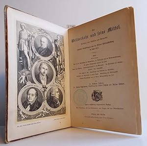
Der Weltverkehr und seine Mittel
Publicado por Leipzig und Berlin, Verlagsbuchhandlung von Otto Spamer, 1875, 1875
Pappband, 4° 18 x 25 cm), 732 S., 2., vollständig umgearbeitete Auflage, mit elf Tonbildern, 350 Text-Illustrationen, einer Flaggen- und einer Weltverkehrskarte (diese fehlen), Rundschau über Schiffahrt und Welthandel, Industrieausstellungen und die Wiener Weltausstellung im Jahre 1873, Inhalt: Blick auf die Entwicklung des Großverkehrs, der Volksarbeit und der Welthandelsbewegung - Die großen Verkehrswege vormals und heute - Posten und Postwesen - Kommunikationsmittel in den Metropolen - Die Eisenbahnen als Verkehrsstraßen - Das Dampfschiff - Das Schiff in See - Einrichtungen zur Sicherung des Seeverkehrs - Schiffahrt und Seeverkehr in unseren Tagen - Entwicklung der Welttelegraphie - Industrieausstellungen und die Wiener Weltausstellung von 1873 Einband Gebrauchsspuren und berieben, Aufkleber auf dem Rücken, Stempel auf Vorsatz- und Titelblatt, durch unfachgemäßen Schnitt Seiten teilweise bestoßen.
-
Der Weltverkehr und seine Mittel. Rundschau über Schiffahrt und Welthandel. Industrie-Ausstellungen und die Wiener Weltausstellung im Jahre 1873. Prachtband.
Publicado por Spamer, Leipzig, 1875
Libro
Halblederband. Condición: Gut. 2., vollständig umgearbeitete Auflage, VII/732 Seiten, mit 11 Tonbildern, 350 Textillustrationen, einer Flaggen- und einer farbigen Klapp-Weltverkehrskarte. Der Einbandrücken war eingerissen und wurde grob repariert, der Einband weist Gebrauchsspuren auf und ist an den Ecken bestoßen. Der Buchblock ist nach der 1. und letzten Lage (zwischen den Seiten 16+17 bzw. 712+713) gebrochen, ansonsten altersgemäßer Zustand, Groß-8°. (=Das neue Buch der Erfindungen, Gewerbe und Industrien. Rundschau auf allen Gebieten der gewerblichen Arbeit. Ergänzungsband). Umfaßt die Entwicklung des Großverkehrs einschließlich der wichtigsten Verkehrswege zu Land und zu Wasser, des Post- und Kommunikationswesens (Telegraphie!) sowie einen Überblick über Industrieausstellungen und die Wiener Weltausstellung von 1873. - Das Frontispiz zeigt Porträts einiger für die Entwicklung der Seefahrt und des Verkehrswesens wichtiger Persönlichkeiten. Die Tafeln mit historischen Darstellungen, Architekturen, Ansichten u.a. geben die Weltverkehrswege, ferner Kriegs- und Handelsflaggen wieder. Sprache: Deutsch Gewicht in Gramm: 1850.
-

Kaufmännische Unterrichtsstunden, 5. Band: Handels- und Verkehrsgeographie. Mit geschichtlichen Rückblicken.
Publicado por Julius Maier, Stuttgart, 1871
Librería: Elops e.V. Offene Hände, Bad Windsheim, Alemania
Valoración del vendedor:
Libro
406 S. Einbandrücken verblaßt, Buchblock Stockflecke und Feuchtigkeitsflecke, Textmarkierungen, Buchschnitt blau; Frakturschrift; Vorsatz geknickt Sprache: Deutsch Gewicht in Gramm: 500 Hartpappe, 21 cm, Hardcover/Pappeinband.
-
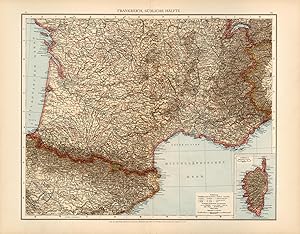
Frankreich, Suedliche Haelfte (France, Southern Half)
Ańo de publicación: 1893
Librería: Art Source International Inc., Boulder, CO, Estados Unidos de America
Valoración del vendedor:

This map by Dr. Richard Andree (1835-1912), for his General Hand Atlas, is a wonderful example of the fine German engraving work. The detail noting even the smallest of villages is extraordinary. This map measures 16.5 inches by 21.5 inches.
-
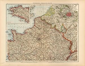
Frankreich, Noerdliche Haelfte (France, Northern Half)
Ańo de publicación: 1893
Librería: Art Source International Inc., Boulder, CO, Estados Unidos de America
Valoración del vendedor:
This map by Dr. Richard Andree (1835-1912), for his General Hand Atlas, is a wonderful example of the fine German engraving work. The detail noting even the smallest of villages is extraordinary. This map measures 16.5 inches by 21.5 inches.
-
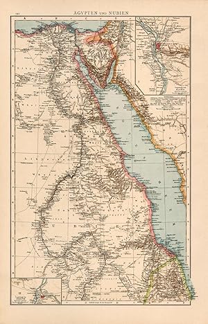
Aegypten und Nubien (Egypt and Nubia)
Ańo de publicación: 1893
Librería: Art Source International Inc., Boulder, CO, Estados Unidos de America
Valoración del vendedor:
This map by Dr. Richard Andree (1835-1912), for his General Hand Atlas, is a wonderful example of the fine German engraving work. The detail noting even the smallest of villages is extraordinary. This map measures 16.5 inches by 11 inches.
-
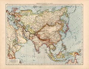
Uebersichtskarte Asien Asia
Ańo de publicación: 1893
Librería: Art Source International Inc., Boulder, CO, Estados Unidos de America
Valoración del vendedor:
This map by Dr. Richard Andree (1835-1912), for his General Hand Atlas, is a wonderful example of the fine German engraving work. The detail noting even the smallest of villages is extraordinary. This map measures 16.5 inches by 21.5 inches.
-
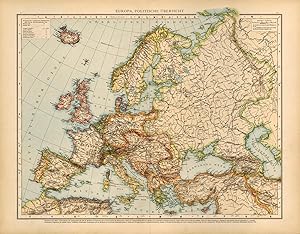
Europa, Politische Uebersicht (Europe, Political Overview)
Ańo de publicación: 1893
Librería: Art Source International Inc., Boulder, CO, Estados Unidos de America
Valoración del vendedor:
This map by Dr. Richard Andree (1835-1912), for his General Hand Atlas, is a wonderful example of the fine German engraving work. The detail noting even the smallest of villages is extraordinary. This map measures 16.5 inches by 21.5 inches.
-
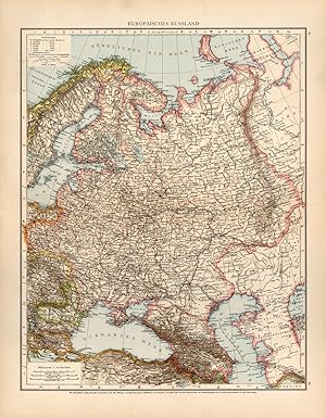
Europaeisches Russland (European Russia)
Ańo de publicación: 1893
Librería: Art Source International Inc., Boulder, CO, Estados Unidos de America
Valoración del vendedor:
This map by Dr. Richard Andree (1835-1912), for his General Hand Atlas, is a wonderful example of the fine German engraving work. The detail noting even the smallest of villages is extraordinary. This map measures 21.5 inches by 16.5 inches.
-
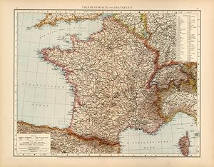
Uebersichtskarte von Frankreich (General map of France)
Ańo de publicación: 1893
Librería: Art Source International Inc., Boulder, CO, Estados Unidos de America
Valoración del vendedor:
This map by Dr. Richard Andree (1835-1912), for his General Hand Atlas, is a wonderful example of the fine German engraving work. The detail noting even the smallest of villages is extraordinary. This map measures 16.5 inches by 21.5 inches.
-
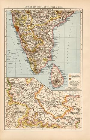
Vorderindien, Suedlicher Teil / Nord-West Provinzen (India, Southern Part / Northwest Provinces)
Ańo de publicación: 1893
Librería: Art Source International Inc., Boulder, CO, Estados Unidos de America
Valoración del vendedor:
This map by Dr. Richard Andree (1835-1912), for his General Hand Atlas, is a wonderful example of the fine German engraving work. The detail noting even the smallest of villages is extraordinary. This map measures 16.5 inches by 11 inches.
-
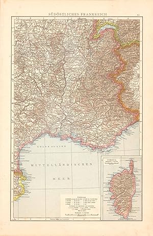
Sudostliches Frankreich (Southeast France)
Ańo de publicación: 1887
Librería: Art Source International Inc., Boulder, CO, Estados Unidos de America
Valoración del vendedor:
This wonderful map was published by Dr. Richard Andrees in 1887, in Leipzig, Germany. German-made maps of this time period were known for their attention to detail and their fine engraving work. This map of Southeast France is the epitome of fine German printing. This map measures 14.5 inches by 9.5 inches.
-
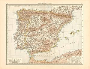
Spanien Und Portugal (Spain and Portugal)
Ańo de publicación: 1887
Librería: Art Source International Inc., Boulder, CO, Estados Unidos de America
Valoración del vendedor:
This wonderful map was published by Dr. Richard Andrees in 1887, in Leipzig, Germany. German-made maps of this time period were known for their attention to detail and their fine engraving work. This map of Spain and Portugal is the epitome of fine German printing. This map measures 14.5 inches by 18 inches.
-
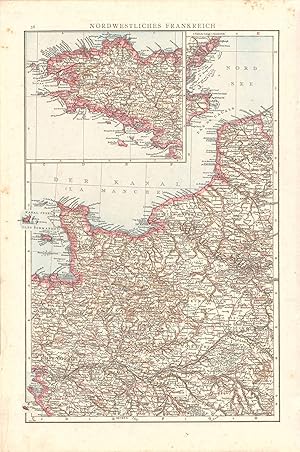
Nordwestliches Frankreich (Northwest France)
Ańo de publicación: 1887
Librería: Art Source International Inc., Boulder, CO, Estados Unidos de America
Valoración del vendedor:
This wonderful map was published by Dr. Richard Andrees in 1887, in Leipzig, Germany. German-made maps of this time period were known for their attention to detail and their fine engraving work. This map of Northwest France is the epitome of fine German printing. This map measures 14.5 inches by 9.5 inches.
-
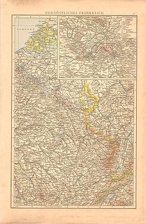
Nordostliches Frankreich (Northeastern France) with inset map of Paris
Ańo de publicación: 1887
Librería: Art Source International Inc., Boulder, CO, Estados Unidos de America
Valoración del vendedor:
This wonderful map was published by Dr. Richard Andrees in 1887, in Leipzig, Germany. German-made maps of this time period were known for their attention to detail and their fine engraving work. This map of Northeastern France is the epitome of fine German printing. This map measures 14.5 inches by 9.5 inches.
-
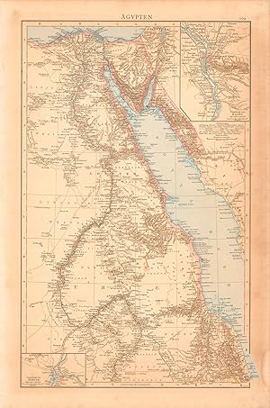
Agypten (Egypt)
Ańo de publicación: 1887
Librería: Art Source International Inc., Boulder, CO, Estados Unidos de America
Valoración del vendedor:
This wonderful map was published by Dr. Richard Andrees in 1887, in Leipzig, Germany. German-made maps of this time period were known for their attention to detail and their fine engraving work. This map of Egypt is the epitome of fine German printing. This map measures 14.5 inches by 9.25 inches.
-
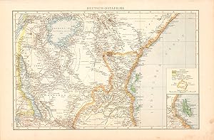
Deutsch-Ostafrika (German East Africa)
Ańo de publicación: 1887
Librería: Art Source International Inc., Boulder, CO, Estados Unidos de America
Valoración del vendedor:
This wonderful map was published by Dr. Richard Andrees in 1887, in Leipzig, Germany. German-made maps of this time period were known for their attention to detail and their fine engraving work. This map of German East Africa is the epitome of fine German printing. This map measures 9.25 inches by 14.5 inches.
-
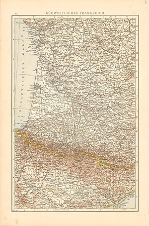
Sudwestliches Frankreich (Southwestern France)
Ańo de publicación: 1887
Librería: Art Source International Inc., Boulder, CO, Estados Unidos de America
Valoración del vendedor:
This wonderful map was published by Dr. Richard Andrees in 1887, in Leipzig, Germany. German-made maps of this time period were known for their attention to detail and their fine engraving work. This map of Southwestern France is the epitome of fine German printing. This map measures 14.5 inches by 9.5 inches.
-
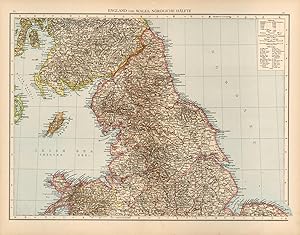
England und Wales, Noerdliche Haelfte (England and Wales, Northern Half)
Ańo de publicación: 1893
Librería: Art Source International Inc., Boulder, CO, Estados Unidos de America
Valoración del vendedor:
This map by Dr. Richard Andree (1835-1912), for his General Hand Atlas, is a wonderful example of the fine German engraving work. The detail noting even the smallest of villages is extraordinary. This map measures 16.5 inches by 21.5 inches.
-
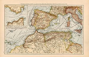
Verkehrskarte der Mittelmeerlaender, Westliche Haelfte (Traffic Map of the Mediterranean Countries, Western Half)
Ańo de publicación: 1893
Librería: Art Source International Inc., Boulder, CO, Estados Unidos de America
Valoración del vendedor:
This map by Dr. Richard Andree (1835-1912), for his General Hand Atlas, is a wonderful example of the fine German engraving work. The detail noting even the smallest of villages is extraordinary. This map measures 11 inches by 16.5 inches.
-
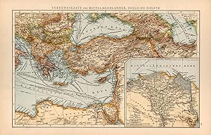
Verkehrskarte der Mittelmeerlaender, Oestliche Haelfte (Traffic Map of the Mediterranean Countries, Eastern Half)
Ańo de publicación: 1893
Librería: Art Source International Inc., Boulder, CO, Estados Unidos de America
Valoración del vendedor:
This map by Dr. Richard Andree (1835-1912), for his General Hand Atlas, is a wonderful example of the fine German engraving work. The detail noting even the smallest of villages is extraordinary. This map measures 11 inches by 16.5 inches.
-
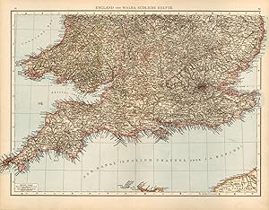
England und Wales, Suedliche Haelfte (England and Wales, Southern Half)
Ańo de publicación: 1893
Librería: Art Source International Inc., Boulder, CO, Estados Unidos de America
Valoración del vendedor:
This map by Dr. Richard Andree (1835-1912), for his General Hand Atlas, is a wonderful example of the fine German engraving work. The detail noting even the smallest of villages is extraordinary. This map measures 16.5 inches by 21.5 inches.
-
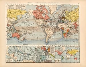
Kolonial und Weltverkehrskarte / Meeresstroemungen (Colonial and International Traffic Map / Ocean Currents)
Ańo de publicación: 1893
Librería: Art Source International Inc., Boulder, CO, Estados Unidos de America
Valoración del vendedor:
This map by Dr. Richard Andree (1835-1912), for his General Hand Atlas, is a wonderful example of the fine German engraving work. The detail noting even the smallest of villages is extraordinary. This map measures 16.5 inches by 21.5 inches.
-
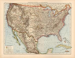
Vereinigte Staaten von Nordamerika (United States of North America)
Ańo de publicación: 1893
Librería: Art Source International Inc., Boulder, CO, Estados Unidos de America
Valoración del vendedor:
This map by Dr. Richard Andree (1835-1912), for his General Hand Atlas, is a wonderful example of the fine German engraving work. The detail noting even the smallest of villages is extraordinary. This map measures 16.5 inches by 21.5 inches.
-
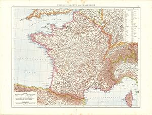
Ubersichtskarte Von Frankreich (Outline Map of France)
Ańo de publicación: 1887
Librería: Art Source International Inc., Boulder, CO, Estados Unidos de America
Valoración del vendedor:
This wonderful map was published by Dr. Richard Andrees in 1887, in Leipzig, Germany. German-made maps of this time period were known for their attention to detail and their fine engraving work. This map of France is the epitome of fine German printing. This map measures 14.5 inches by 18.5 inches.
-
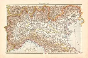
Oberitalien (Northern Italy)
Ańo de publicación: 1887
Librería: Art Source International Inc., Boulder, CO, Estados Unidos de America
Valoración del vendedor:
This wonderful map was published by Dr. Richard Andrees in 1887, in Leipzig, Germany. German-made maps of this time period were known for their attention to detail and their fine engraving work. This map of Northern Italy is the epitome of fine German printing. This map measures 9.5 inches by 14.5 inches.
-
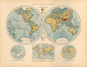
Westliche und Oestliche Halbkugel (Western and Eastern Hemispheres)
Ańo de publicación: 1893
Librería: Art Source International Inc., Boulder, CO, Estados Unidos de America
Valoración del vendedor:
This map by Dr. Richard Andree (1835-1912), for his General Hand Atlas, is a wonderful example of the fine German engraving work. The detail noting even the smallest of villages is extraordinary. This map measures 16.5 inches by 21.5 inches.
-
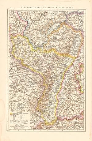
Elsass-Lothringen Und Bayrische Pfalz (Alsace-Lorraine and Bavarian Palatinate)
Ańo de publicación: 1887
Librería: Art Source International Inc., Boulder, CO, Estados Unidos de America
Valoración del vendedor:
This wonderful map was published by Dr. Richard Andrees in 1887, in Leipzig, Germany. German-made maps of this time period were known for their attention to detail and their fine engraving work. This map of Alsace-Lorraine and Bavarian Palatinate is the epitome of fine German printing. This map measures 14.5 inches by 9.25 inches.
