Europe Executive Flat: Wall Maps Continents (National Geographic Reference Map)
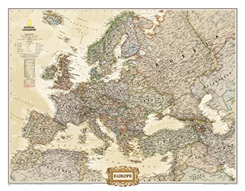

Mapa de Europa actualizado, realizado por National Geographic con estilo de colores clßsicos. Este mapa, el Executive de Europa es un mapa polÝtico con gran detalle, con la garantÝa de elaboraciˇn de National Geographic. Se trata de un mapa ideal tanto para un uso documental como para la decoraciˇn de oficinas, despacho o sala de reuniones. Idioma: InglÚs Medidas: 76 x 61 cm Escala 1:8.425.000 Embalado en tubo de plßstico protector
"Sinopsis" puede pertenecer a otra ediciˇn de este libro.
Rese˝a del editor:
The Executive political map of Europe is a striking example of the cartographic excellence National Geographic is known for. The antique color palette, shaded relief, and easy-to-read fonts make this map both beautiful and functional. International boundaries are clearly defined and thousands of place names, waterbodies, airports, major highways and roads, national parks and more are included.
This map includes complete coverage of the countries and major cities of Albania, Armenia, Austria, Azerbaijan, Belarus, Belgium, Bosnia & Herzegovina, Bulgaria, Croatia, Cyprus, Czech Republic, Denmark, Estonia, Finland, France, Georgia, Germany, Greece, Hungary, Iceland, Ireland, Italy, Kosovo, Latvia, Liechtenstein, Lithuania, Luxembourg, Macedonia, Moldova, Montenegro, The Netherlands, Norway, Poland, Portugal, Romania, Russia, Serbia, Slovakia, Slovenia, Spain, Sweden, Switzerland, Turkey, Ukraine, and the United Kingdom.
- Map Scale = 1:8,425,000
- Sheet Size = 30.5" x 23.75"
"Sobre este tÝtulo" puede pertenecer a otra ediciˇn de este libro.
- EditorialNational Geographic Maps
- A˝o de publicaciˇn2012
- ISBN 10 0792289811
- ISBN 13 9780792289814
- EncuadernaciˇnMapa
- N˙mero de pßginas1
(Ning˙n ejemplar disponible)
Buscar: Crear una peticiˇnSi conoce el autor y el tÝtulo del libro pero no lo encuentra en IberLibro, nosotros podemos buscarlo por usted e informarle por e-mail en cuanto el libro estÚ disponible en nuestras pßginas web.
Crear una peticiˇn