United Kingdom: Wall Map (Collins Primary Atlases) - Tapa blanda
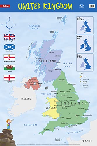

Every primary school needs this brightly coloured map of the UK, including the Channel Islands and the Isle of Man. Uncluttered with unnecessary detail, major town and city names are clearly labelled. Political colours, clear lettering and symbols used for easy reference make it ideal for teaching the location of places.Maps are a fundamental teaching tool., `Where' makes a lesson real and puts it into context.Alongside the large political map is a series of small thematic maps illustrating clearly the correct use of the terms United Kingdom, British Isles and Great Britain.This wall chart is laminated on one side and supplied rolled and shrink-wrapped. It is ideal for mounting on a classroom wall or for home study.Dimensions 915 X 610 mmMakes learning fun.Published in association with the Geographical Association.
"Sinopsis" puede pertenecer a otra edición de este libro.
Biografía del autor:
Explore the world through accurate and up-to-date mapping.
"Sobre este título" puede pertenecer a otra edición de este libro.
- EditorialHarper Collins
- Ańo de publicación2014
- ISBN 10 0007536127
- ISBN 13 9780007536122
- EncuadernaciónTapa blanda
- Número de edición1
- Número de páginas1
(Ningún ejemplar disponible)
Buscar: Crear una peticiónSi conoce el autor y el título del libro pero no lo encuentra en IberLibro, nosotros podemos buscarlo por usted e informarle por e-mail en cuanto el libro esté disponible en nuestras páginas web.
Crear una petición![9780008212087: Children’s Wall Map of the United Kingdom and Ireland (Maps) [Idioma Inglés]: Ideal way for kids to improve their UK knowledge](http://assets.prod.abebookscdn.com/cdn/shared/images/common/loading/collections-spinner.gif)